Titan Images 2011

The photo in the lower part of the table reveals the colorful disc of Saturn's largest moon Titan in front of the rings of the Ringed Planet. One can notice the famous dark polar hood of the northern hemisphere of the Orange Moon as well as the detached haze layer of its outer atmosphere.
The camera is orientated toward the northern, illuminated side of the rings from just above the ring plane. This natural color view was obtained with the Narrow-Angle Camera of the Cassini probe on May 21, 2011 at a distance of about 1.4 million miles or 2.3 million kilometers from the Opaque Moon. The color view was generated on the basis of images captured using red, green and blue spectral filters.
The second photo from the lower part of the table shows the Orange Moon Titan and the bright Dione which can be seen through the haze of Titan. The Gas Giant Saturn and its rings appear in the background.
The dark polar hood of Titan's northern hemisphere can be noticed as well as the bright streaks of Dione. North on each moon is up. The camera of the Cassini probe is orientated toward the sides of the moons facing away from Saturn and toward the northern, illuminated side of the rings from just above the ring plane.
This natural color view is based on the combination of images acquired using red, green and blue spectral filters. The views were taken with the Narrow-Angle Camera of the Cassini spacecraft on May 21, 2011 at a distance of approximately 1.4 million miles or 2.3 million kilometers from the Orange Moon and 2 million miles or 3.2 million kilometers from Dione.
The third photo from the lower part of the table reveals the bright, icy Tethys as well as the Opaque Moon Titan appearing in front of the rings of Saturn. Tethys is moving behing the rings. The dark polar hood of Titan's northern hemisphere is clearly visible in this view. The eyes can see Ithaca Chasma running north-south on the icy moon Tethys. Ithaca Chasma corresponds to a long series of cliffs or scarps.
The camera is orientated toward the side of the Opaque Moon facing away from Saturn and the side of Tethys facing the Gas Giant. The camera is also orientated toward the northern, illuminated side of the rings from just above the ring plane.
This natural color image was generated on the basis of the combination of views acquired using red, green and blue spectral filters. The views were obtained with the Narrow-Angle Camera of the Cassini probe on May 21, 2011 at a distance of approximately 1.4 million miles or 2.3 million kilometers from the Orange Moon and 2.4 million miles or 3.8 million kilometers from Tethys.
The fourth photo from the lower part of the table shows the bright, icy Dione as well as Saturn's largest moon Titan. Dione appears bigger than Titan in this view because Titan is moving much farther from the camera than Dione.
The image was taken at a distance of about 684,000 miles or 1.1 million kilometers from the Orange Moon and only about 85,000 miles or 136,000 kilometers from the bright Dione. The camera is orientated toward the Saturn-facing side of Titan and the area between the Saturn-facing side and the leading hemisphere of Dione. North is up on each moon.
This natural color view was created on the basis of the combination of views obtained using red, green and blue spectral filters. Let's note that Titan has been brightened by a factor of approximately 1.6 relative to Dione. The views were captured with the Wide-Angle Camera of the Cassini spacecraft on November 6, 2011. The view has been magnified by a factor of 1.5 and contrast-enhanced to improve visibility.
The view in the upper part of the table reveals two images of Titan's atmosphere. The close-up image in the lower portion of the view, obtained with the Narrow-Angle Camera of the Cassini spacecraft, unveils the outer atmosphere of Titan in the south polar region of the moon. The image in the upper part of the view, showing a larger portion of Titan, was obtained a second later with the Wide-Angle Camera of the Cassini probe.
One can notice a depression within the orange and blue haze layers near the south pole of Saturn's largest moon. The contrast in colors between the high altitude haze layer which appears blue and the lower portion of the atmosphere which appears orange may be related to particle size of the haze. The blue haze probably consists of smaller particles than the orange haze.
The compressed or depressed layer can be found in the transition area between the orange and blue hazes approximately a third of the way in from the left rim of the narrow-angle view. The south pole can be identified in the upper right of this view. The north polar vortex or hood may be starting to migrate or change its position from north to south due to changes in seasons. The winter season came to an end in August 2009 with the equinox and the start of the spring season in the northern hemisphere. As the summer season is approaching in the northern hemisphere, the north polar vortex may progressively lose its strength or its volume.
The southern hemisphere is now approaching the winter season. A polar vortex may also take shape in the south polar region since the area is going into darkness with each passing day. The upper portion of the hazes of the Opaque Moon is still illuminated by sunlight.
This natural color image was obtained on the basis of the combination of red, green and blue spectral filters. The photos were taken on September 11, 2011 at a distance of approximately 83,000 miles or 134,000 kilometers from the Orange Moon.

Image Credit: NASA/JPL-Caltech/Space Science Institute


This near-infrared image of the disk of Titan unveils Kraken Mare, the largest body of liquid identified in the high latitudes of the northern hemisphere. The dark patch of Kraken Mare can be found in the upper part of the disk. Kraken Mare is likely composed of liquid hydrocarbons. The liquid may be composed of a mixture of methane and ethane.
The image was obtained with the narrow-angle camera of the Cassini probe on September 14, 2011 using a spectral filter sensitive to wavelengths of near-infrared radiation centered at 938 nanometers. The view was taken at a distance of about 1.2 million miles or 1.9 million kilometers from the Orange Moon and at a Sun-Titan-spacecraft, or phase, angle of 26 degrees. The camera is orientated toward the Saturn-facing side of Titan. North on the Opaque Moon is up and rotated 29 degrees to the left.

Image Credit: NASA/JPL-Caltech/Space Science Institute


This image corresponds to an updated map of the Orange Moon Titan. The digital map was generated on the basis of images obtained by the Imaging Science Subsystem (ISS) of the Cassini spacecraft. The views were captured using a filter centered at 938 nanometers because they allow researchers to observe and analyze the surface or the topography via variations in albedo or brightness across the surface of Saturn's largest moon. The views don't reveal any topographic shading due to the scattering of light by the deep, thick, dense and opaque atmosphere of the Orange Moon.
The digital map corresponds to an equidistant projection of the globe. It has a scale of 2.5 miles or 4 kilometers per pixel. The resolution in the map is not homogeneous. It varies greatly across the map. The best coverage can be found along the equator near the center of the map at 180 degrees west longitude and near the left and right limits at 0 and 360 degrees west longitude. By contrast, the worst coverage appears in some northern latitudes and on the leading hemisphere, notably, around 120 degrees west longitude. The coverage in the north polar region is progressively improving as the area comes out of shadow and as the Spring season advances in the area. The north polar sea Kraken Mare, likely made of liquid hydrocarbons, can be clearly noticed in this view.
This map takes into account data acquired up to April 2011. Thus, it improves the former map of February 2009 with an improved coverage in the southern trailing hemisphere and over portions of the north polar area. The equidistant projection is based on the assumption that Titan is spherical and that the mean radius is 1,600 miles or 2,575 kilometers. As a result, the accuracy is limited until a control network, or a model of the moon's shape based on several views tied together at defined points on the ground, is produced in the future.
This map clearly shows the well-known areas of Titan, from the dark Senkyo and the dark Belet on the left to the bright Adiri and the dark Shangri-La in the middle, in the equatorial or tropical region and from the bright Xanadu to the dark Fensal/Aztlan in the low latitudes, to the right of the view.

Image Credit: NASA/JPL-Caltech/Space Science Institute


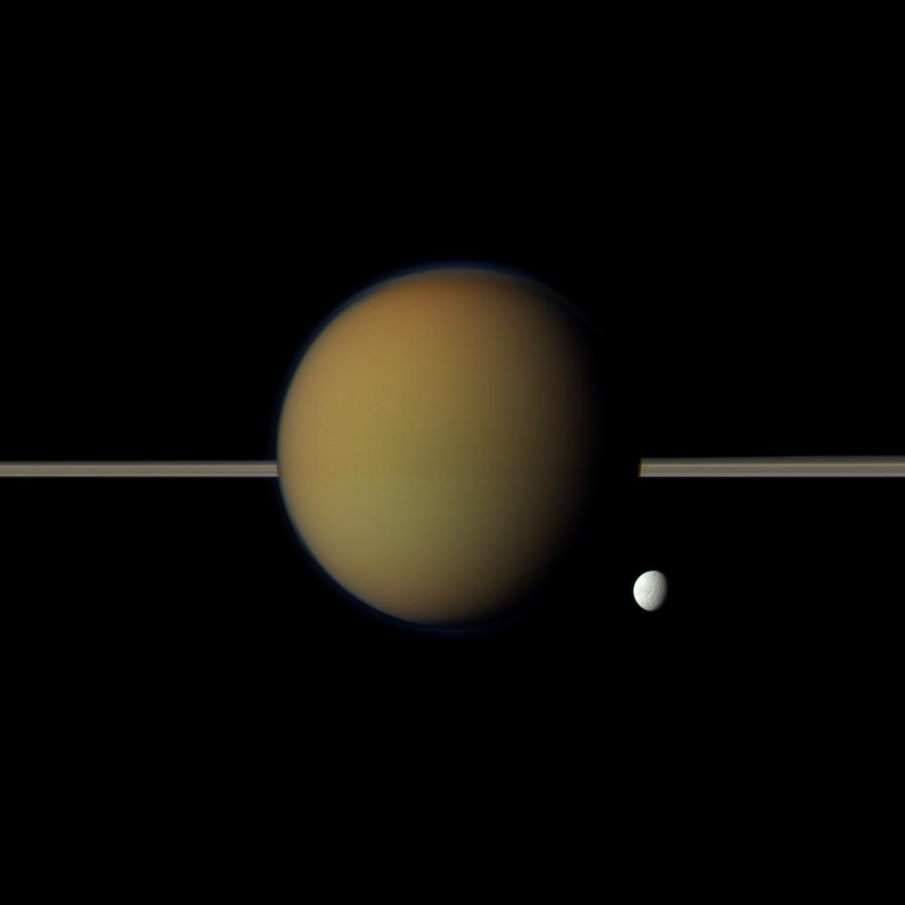
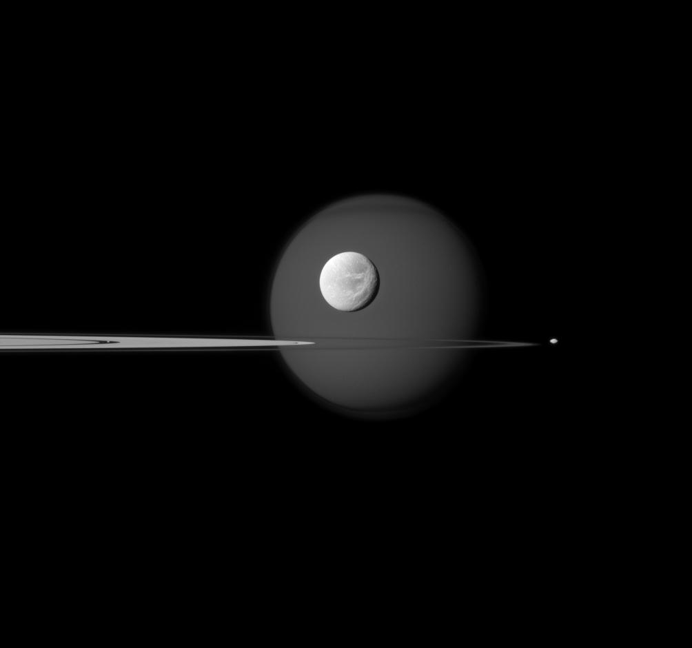
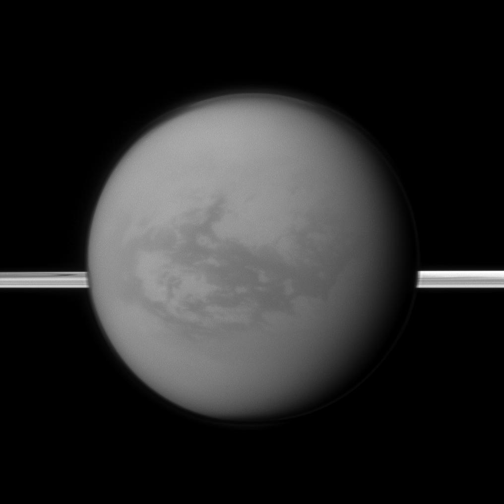
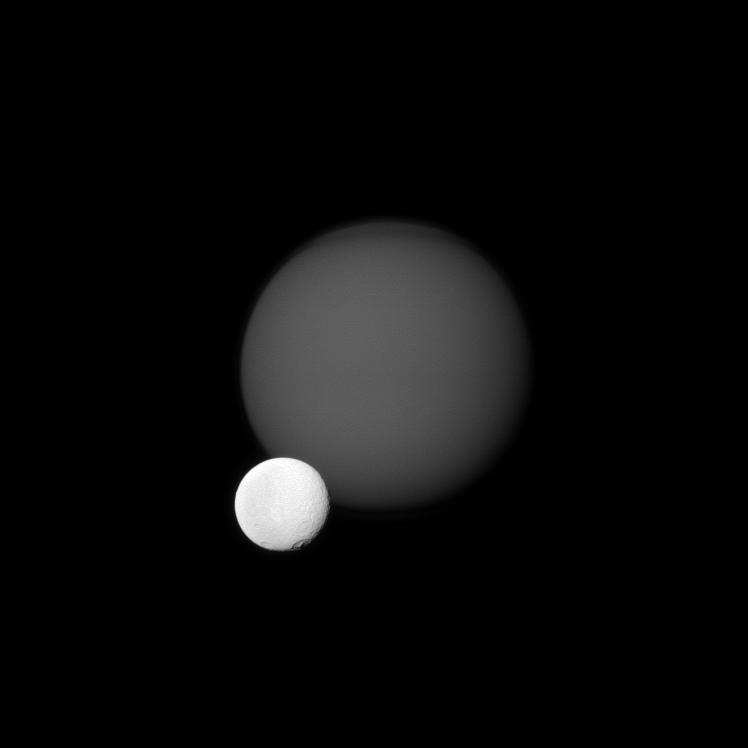
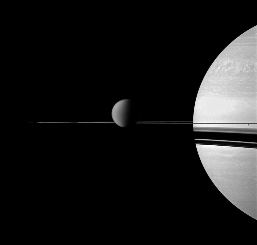
This view obtained in visible blue light with the narrow-angle camera of the Cassini probe on September 17, 2011 reveals a portion of Saturn's rings as well as four of its moons, the bright Dione, the Opaque Moon Titan behind it, Pan in the Encke Gap of the A ring on the left of the view and Pandora which can be found beyond the rings on the right of the view.
The photo was taken at a distance of about 1.3 million miles or 2.1 million kilometers from Dione and at a Sun-Dione-probe, or phase, angle of 27 degrees. The camera is orientated toward the illuminated side of the rings from just above the ringplane.
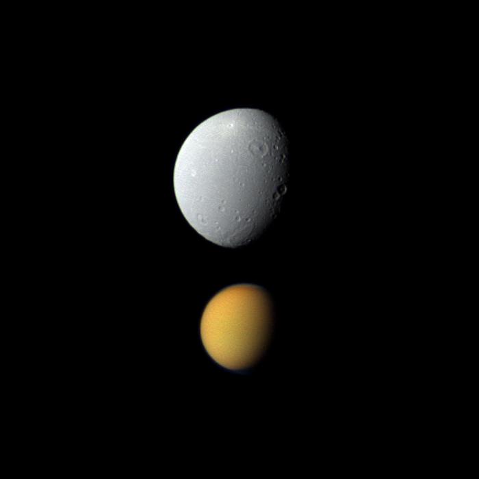
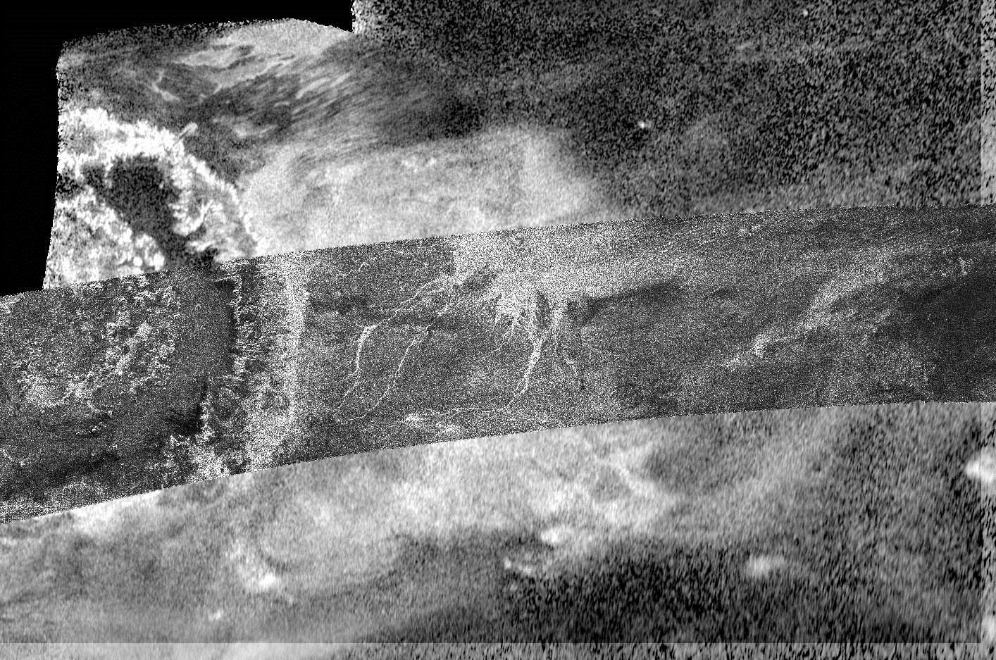
The bright Dione, approximately 1,123 km or 698 miles in diameter, which appears just above the rings in the middle of the view, unveils its fractured or wispy terrain that can be found in the trailing hemisphere of the icy moon. Dione orbits Saturn at a mean distance of about 377,396 km or 235,000 miles.
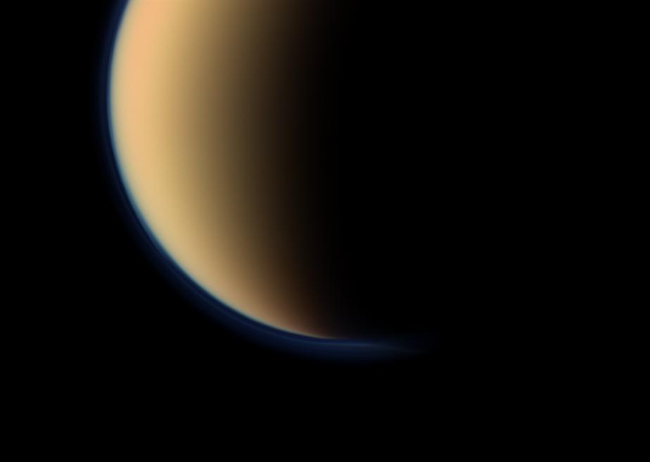
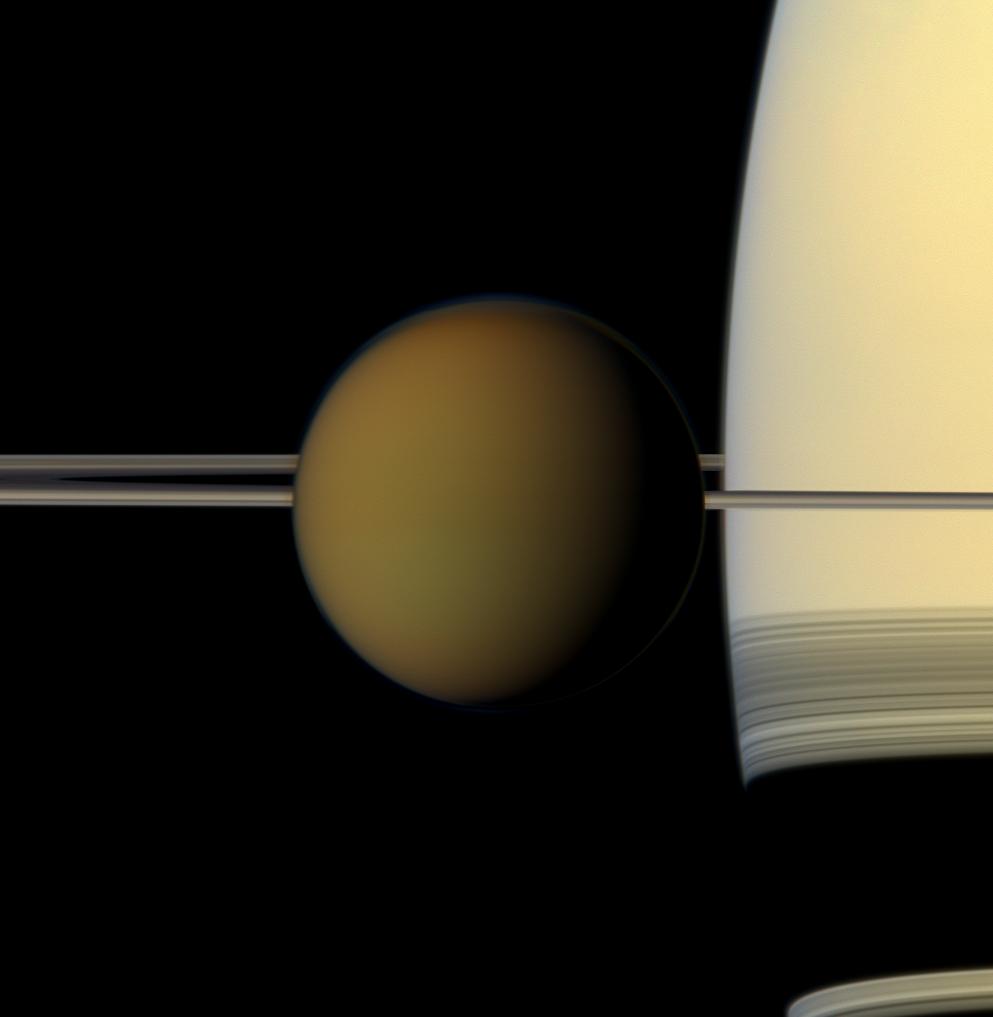
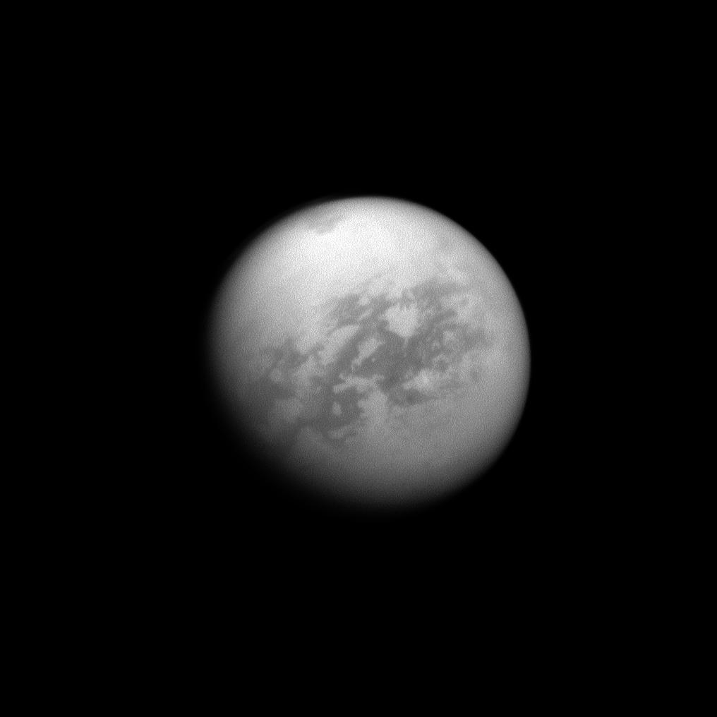
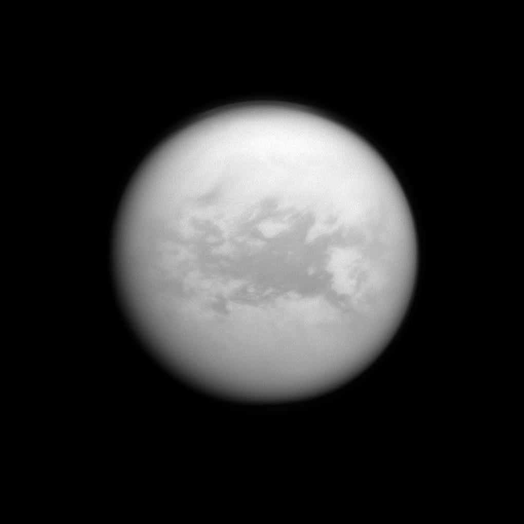
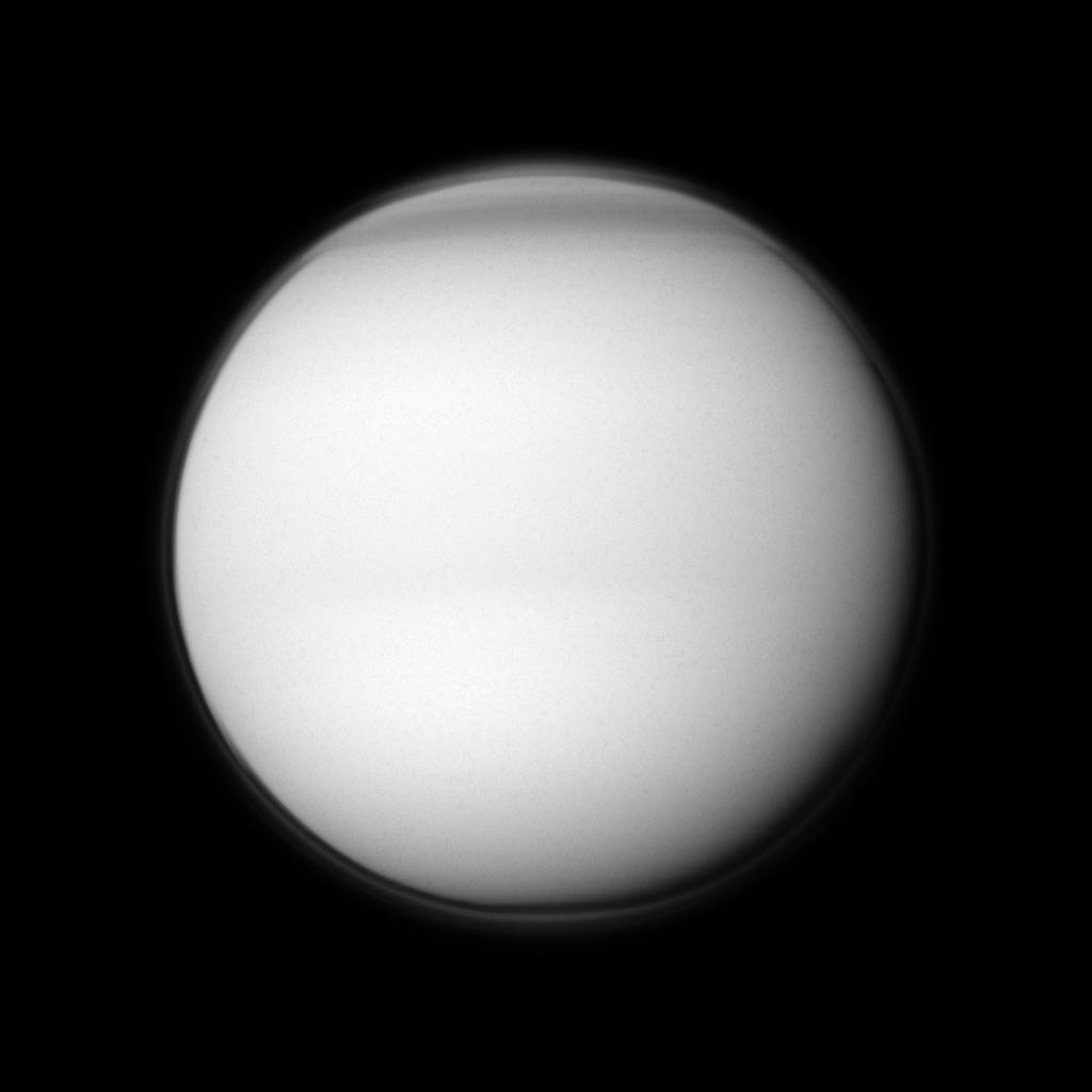
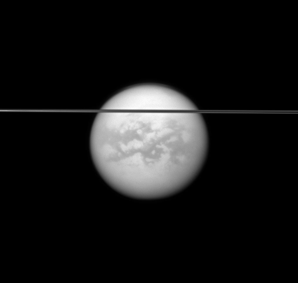
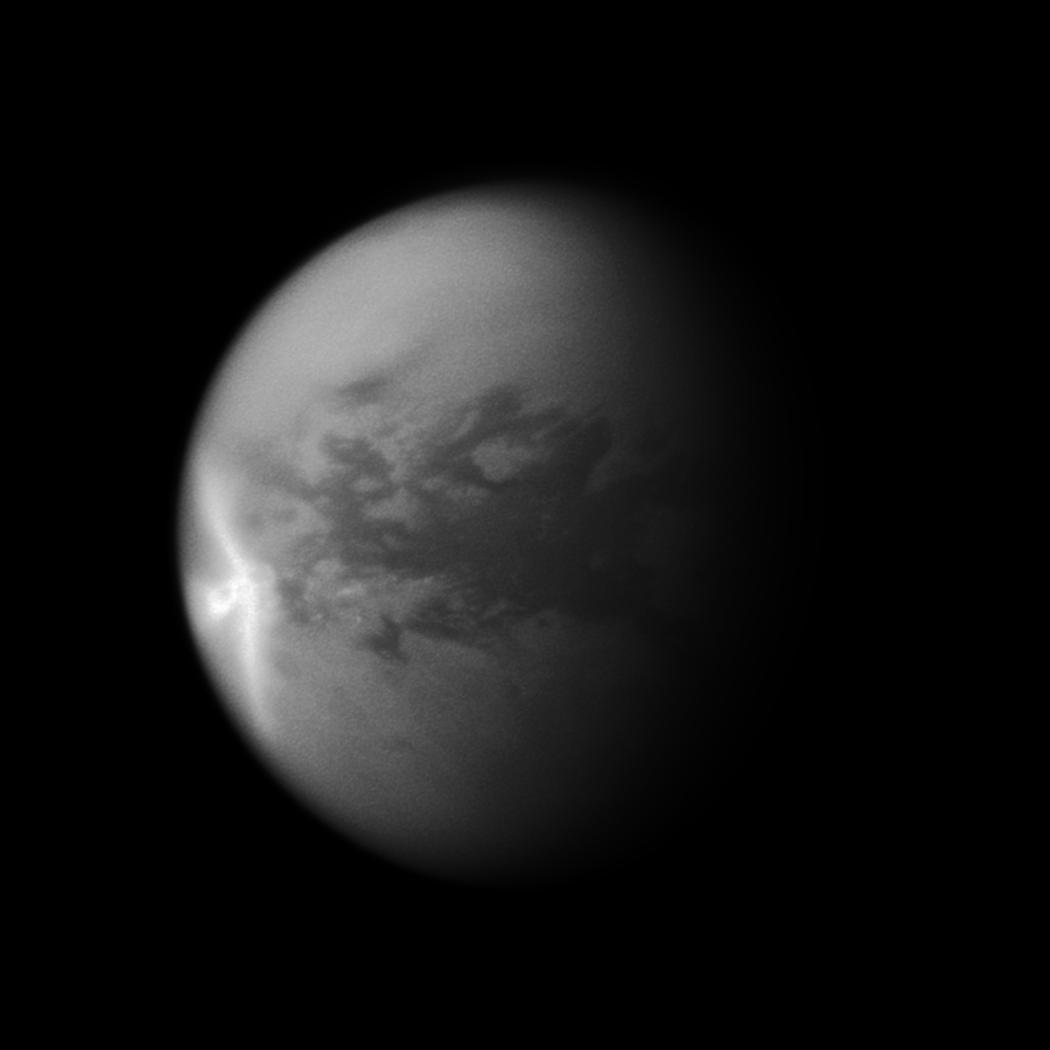
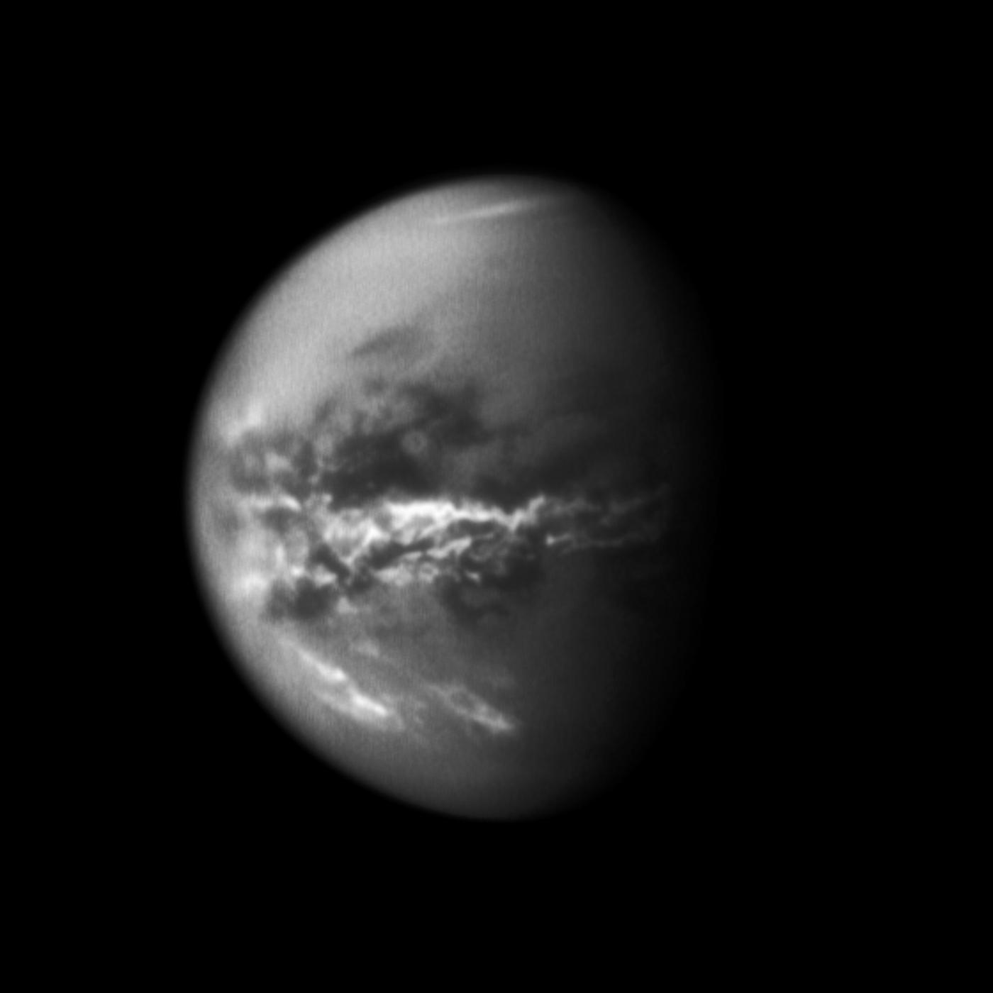
The Orange Moon Titan, approximately 5,150 km or 3,200 miles in diameter, appearing in the background of the image, reveals its thick and opaque atmosphere as well as its dark north polar hood. Titan orbits Saturn at a mean distance of about 1,221,870 km or 760,000 miles.
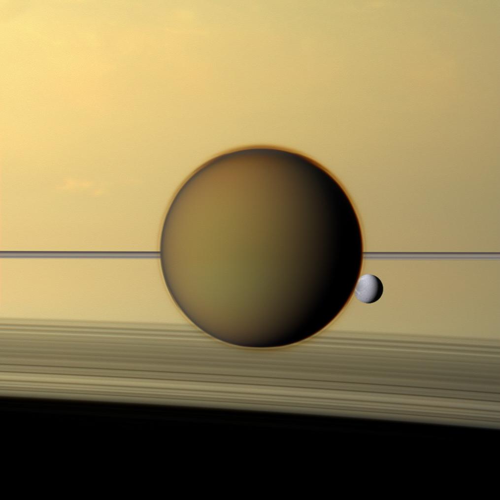
The small icy moon Pandora, approximately 81 kilometers or 50 miles in diameter, unveils its oval shape to the right of the rings. Pandora orbits Saturn at a mean distance of about 141,720 km or 88,500 miles.
The walnut-shaped moon Pan, approximately 28 kilometers or 17 miles in diameter, which can be found in the Encke Gap of the ring system, swallows the ring particles in its surroundings. Pan orbits the gas giant Saturn at a mean distance of about 133,584 kilometers or 83,000 miles.

Image Credit: NASA/JPL-Caltech/Space Science Institute


The global mosaic of VIMS infrared images of Titan, above, is based on images obtained during the nominal and equinox Cassini mission. The views were generated by a team led by the University of Nantes (France) and Stéphane Le Mouélic. The contrast in colors is related to differences in composition of the surface of Saturn's largest moon.
The landscape is not homogeneous in appearance and composition. The dark areas observed in the low latitudes of the Orange Moon are dominated by Seif Dunes or linear and parallel dune fields extending over long distances. Prevailing winds play a key role in shaping those brownish extra-terrestrial dunes. The bright areas are likely composed of water ice or frozen carbon dioxide and they also unveil elevated terrains.
The color coding used in this mosaic is red for 5 µm, green for 2.0 µm and blue for 1.27 µm. The work was presented on October 4, 2011 at the EPSC-DPS Joint Meeting 2011 in Nantes.
The dark Fensal/Aztlan can be clearly identified in the upper right disc of the mosaic. The bright Xanadu, shown in the lower left disc, appears between the dark Shangri-La and the dark Fensal/Aztlan.

Image Credit: JPL/NASA/University of Arizona/CNRS/LPGNantes


The near-infrared view above shows the disc of Saturn's largest moon Titan as well as a portion of Saturn's rings behind the Opaque Moon. One can observe landscape details thanks to brightness variations of the surface. The bright Adiri and the dark Shangri-La appearing eastward from Adiri are clearly visible in the equatorial and tropical region. Atmospheric features such as high-altitude layers or the north polar hood can also be noticed. The Huygens probe landed in the area of Adiri and Shangri-La on January 14, 2005.
This image was obtained from the ISS narrow-angle camera of the Cassini spacecraft on August 9, 2011 using a spectral filter sensitive to wavelengths of near-infrared radiation centered at 938 nanometers. The view was taken at a distance of about 1.4 million kilometers or 870,000 miles from the Orange Moon and at a Sun-Titan-probe, or phase, angle of 35 degrees.
The anti-Saturn side of the moon can be seen here. North on Titan can be found in the upper part of the view. The camera is orientated toward the northern, illuminated side of the rings from just above the ringplane.

Image Credit: NASA/JPL-Caltech/Space Science Institute


This radar view of the surface of Saturn's largest moon Titan corresponds to a portion of the radar swath obtained with the Radar Mapper of the Cassini probe during the flyby of December 12, 2006.
The radar antenna was orientated toward the Opaque Moon at an altitude of 1,000 kilometers or 621 miles during the closest approach. The view has been processed with a resolution of 128 pixels per degree.
The image clearly reveals the Seif dunes which are widespread in the dark areas of the low latitudes of the Orange Moon. The reflective or bright areas in this view tend to deflect the orientation of the linear and parallel dunes shaped by prevailing winds.

Image Credit: NASA/JPL-Caltech
PS: The scale was incorporated into the radar portion by Marc Lafferre. The accuracy of the scale is not guaranteed.


The radar portion above reveals what appears to be the eighth clearly identified impact crater on Saturn's largest moon, Titan.
This landscape portion corresponds to a Synthetic-Aperture Radar (SAR) image acquired from the Radar Mapper of the Cassini spacecraft on June 21, 2011. The view is centered at 12 degrees north latitude and 45 degrees west longitude and it measures 150 miles or 242 kilometers high by 160 miles or 257 kilometers wide. North is in the upper part of the view. The radar image is illuminated from the bottom and incidence angle ranges from 15 to 25 degrees.
The bright circular feature seems to correspond to an impact crater in the area of Fensal/Aztlan. Impact craters are not widespread on the Opaque Moon due to the disintegration effects generated by the deep, dense and opaque atmosphere on any comet or meteorite. The bigger meteorites can reach the surface but strong erosional processes, via winds or rainfall, significantly modify the shape of the craters over time.
One can observe, here, that Seif Dunes dominate the area. Their orientation tends to be deflected by the bright crater. The crater is approximately 25 miles or 40 kilometers in diameter. A bright blanket of ejecta, around it, extends about 10 to 12 miles or 15 to 20 kilometers beyond the rim. The new crater resembles the crater Sinlap which was identified by the Radar Mapper in February 2005 and the crater Ksa which was observed in September 2006.
One can notice that the new crater has steep inward-facing walls and flat, relatively uniform floors like the crater "Sinlap". The crater "Ksa" shows a bright central peak which is absent in this new crater. It is often hard to analyze a crater because it might also correspond to a caldera or a cryovolcano.

Image Credit: NASA/JPL-Caltech


The narrow-angle camera of the Cassini probe unveils the optically-dark region Belet as well as the bright Adiri to the right in this view of Titan's disk.
The image was obtained on June 23, 2011 at a distance of about 1.6 million kilometers or 990,000 miles from the Orange Moon and at a Sun-Titan-probe, or phase, angle of 14 degrees. The view was acquired using a spectral filter sensitive to wavelengths of near-infrared radiation centered at 938 nanometers. The camera is orientated toward the trailing hemisphere of the Opaque Moon and north is in the upper part of the view.
The low-albedo area Belet is known to be dominated by Seif Dunes sculpted by prevailing winds and erosion. This image of the disk also reveals the upper part of Titan's hazy atmosphere.

Image Credit: NASA/JPL-Caltech/Space Science Institute


The radar portion above corresponds to a landscape portion of a radar swath acquired by the Radar Mapper of the Cassini spacecraft during a flyby on July 22, 2006. The radar antenna was orientated toward the Orange Moon at an altitude of 950 kilometers or 590 miles during the closest approach. The view has been processed with a resolution of 128 pixels per degree. The radar swath can be obtained within the NASA Planetary Data System.
A scale has been incorporated into the radar portion by Marc Lafferre in order to facilitate the topographic analysis. The area can be found in the high latitudes of Titan's northern hemisphere where multiple lakes, seas and rivers have been clearly identified. The dark patches in this landscape portion represent pools of liquid methane or ethane. The radar swath was obtained during the Winter season in the northern hemisphere. A giant cyclone engulfing the north polar region was identified from the VIMS of the Cassini probe on December 29, 2006. Therefore, the lakes of hydrocarbons identified in this area may be closely related to meteorology rather than internal sources. The area may experience regular rainfalls. The hypotheses of cryovolcanism and subsurface ocean are not ruled out however.

Radar Image Credit: NASA/JPL-Caltech
PS: The scale was incorporated into the radar portion by Marc Lafferre. The accuracy of the scale is not guaranteed.


The radar image above corresponds to a landscape portion of a radar swath obtained by the Radar Mapper of the Cassini probe during a flyby on April 30, 2006. The radar antenna was orientated toward Titan at an altitude of 1,855 kilometers or 1,153 miles during the closest approach. The view has been processed with a resolution of 128 pixels per degree. The radar swath can be obtained within the NASA Planetary Data System.
A scale has been incorporated into the radar portion by Marc Lafferre in order to facilitate the topographic analysis. The area shows, in particular, a roughly circular feature in the upper part of the view. This dark circular feature surrounded by bright edges may correspond to an impact crater. The dark area appears to be dominated by Seif Dunes or parallel and linear dunes. The Seif Dunes are widespread in the dark areas of the Equatorial and Tropical zone. The shape of the dunes is strongly influenced by prevailing winds. Bright topographic obstacles tend to deflect the orientation of the dunes.

Radar Image Credit: NASA/JPL-Caltech
PS: The scale was incorporated into the radar portion by Marc Lafferre. The accuracy of the scale is not guaranteed.


The composite image above shows, in the left portion, the surface of Titan obtained from the Huygens probe on January 14, 2005 and, in the right portion, a dried-up brook in the village of Concorès in the "Département du Lot", in France.
The Huygens probe landed in the area of Adiri and Shangri-La. Several dark drainage channels were observed in the bright Adiri from the Huygens probe during its atmospheric descent. The image of the orange surface revealed what seems to be a dried-up river made of icy pebbles. The soil may be composed of water ice and mixtures of hydrocarbons such as methane, ethane, acetylene and benzene.
The right view, showing a dried-up brook (on August 10, 2011), located in the village of Concorès ("Département du Lot", near Cahors, France) unveils strong erosional processes and pebbles. Pebbles on Titan and in this Terrestrial brook are roughly similar in appearance and in terms of size.
One can notice that the distribution of pebbles is not uniform or homogeneous on Titan. There seems to be a rupture in the distribution of pebbles slightly above the middle of the view. This rupture may correspond to the edges of a dried-up river.
The area seems particularly wet on Titan since many pebbles seem partly buried in a compact ground. The brook of Concorès appears relatively dry even if rainfalls occured in the region a few days before the snapshot.
By clicking on the image, you can obtain image references on the scale and the dimensions of key pebbles in both views.

Image Credit, Left View: ESA/NASA/JPL/University of Arizona
Image Credit, Right View: Marc Lafferre, 2011
Assembling Work Credit: Marc Lafferre, 2011


This composite view made of radar images reveals the crater Menrva as well as several bright channels relatively close to the crater. Menrva is located above Hotei Arcus and the bright Xanadu close to the region of Fensal/Aztlan.
The radar portion is centered at 20 degrees north latitude and 77 degrees west longitude. The overall view is the outcome of the combination of two radar images. The horizontal arc-shaped strip which has the highest resolution, found in the middle of the radar portion, corresponds to a Synthetic-Aperture Radar image obtained on March 26, 2007. The background or the rest of the image, which has a lower resolution, was taken on June 21, 2011, using a technique called HiSAR or High altitude Synthetic Aperture Radar.
The innovative technique HiSAR uses only the center of the radar's beam with a low-resolution radar mode which allows scientists to obtain a wide-angle view of the area since the image is acquired with the Radar Mapper of the Cassini probe particularly far away from Saturn's largest moon.
Thanks to this new technique, we have obtained a larger portion of this captivating region and we can formulate new hypotheses and improve our understanding of this complex topography. The view covers an area 528 miles or 850 kilometers high and 932 miles or 1,500 kilometers wide.
Menrva is a well-defined feature on Titan which may correspond to an impact crater. The edges of the crater are bright and wide implying elevated formations and/or the presence of a reflective material such as water ice. The bright patch in the center of the circular feature is reminiscent of the central peaks of typical impact craters. The hypothesis for cryovolcanism in Menrva is based on weak arguments but it's not ruled out. Menrva could also be a caldera.
To the right of the crater, one can notice enigmatic, bright channels running from a bright area. Are they dried-up rivers? Are they the outcome of the presumed meteoritic impact? Are they cryovolcanic in nature? Similar reflective channels were identified in the region of Hotei Regio and Hotei Arcus.

Image Credit: NASA/JPL-Caltech


This view acquired with the narrow-angle camera of the Cassini probe in visible green light on July 14, 2011 shows the icy moon Tethys in front of Saturn's largest moon Titan.
Tethys is orbiting closer to Saturn than Titan. The image was taken at a distance of about 3.2 million kilometers or 2 million miles from the Orange Moon and at a Sun-Titan-probe, or phase, angle of 18 degrees. The image was obtained at a distance of approximately 1.9 million kilometers or 1.2 million miles from the cratered moon Tethys and at a Sun-Tethys-spacecraft, or phase, angle of 18 degrees.
The small moon Tehys, only 1,062 kilometers or 660 miles in diameter, is devoid of any atmosphere as opposed to the giant moon Titan, 5,150 kilometers or 3,200 miles across which has a deep, thick and opaque atmosphere. Tethys has a very reflective surface suggeting the presence of water ice or frozen carbon dioxide. Giant craters like Odysseus as well as topographic fractures like Ithaca Chasma can be found on this moon.
The camera looks toward the Saturn-facing side of its largest moon and toward the area between the trailing hemisphere and anti-Saturn side of Tethys. The ringed planet, which doesn't appear in the image can be found far to the left of the view.

Image Credit: NASA/JPL-Caltech/Space Science Institute


The landscape portion, above, obtained with the Radar Mapper of the Cassini probe on June 21, 2011 and corresponding to a Synthetic-Aperture Radar image unveils a low-latitude region of Titan made of dunes, bright areas and a well-defined crater.
The view is centered at 11 degrees north latitude and 74 degrees west longitude. The portion covers an area 350 kilometers or 217 miles high by 930 kilometers or 578 miles wide. North is toward the top of the image. The view is illuminated from the upper part with an incidence angle varying from 15 to 30 degrees.
On can notice that linear and parallel dune fields are widespread, extending over long distances in the dark area of the topographic portion. Those dunes are reminiscent of Seif Dunes on our planet which can be found in Egypt or in Namibia (Namib Desert). The radar images reveal that the dark areas of the low latitudes of Titan, from about 30 degrees north latitude to 30 degrees south latitude, are dominated by Seif Dunes shaped by prevailing winds.
In the upper right portion of the view, one can observe a bright area surrounding a dark circular feature corresponding to the crater Ksa, in the region of Fensal-Aztlan. Ksa was first identified from the Cassini spacecraft in 2006. Is Ksa a Caldera, a volcanic formation or a common impact crater?
The radar-bright features tend to appear as topographic obstacles against the movement of dune fields. The bright region from the lower left to the lower center corresponds to a portion of the continent-sized feature known as Xanadu. The dunes and the winds slightly shape or overlap its edges. The bright material of Xanadu may be different in nature from the material of the typical dunes because it is optically reflective with a relatively high albedo or brightness.

Image Credit: NASA/JPL-Caltech


This view of Saturn's largest moon Titan obtained in visible violet light from the wide-angle camera of the Cassini probe on April 19, 2011 clearly shows the north polar hood which corresponds to the darker part of the atmosphere appearing above the north polar region.
The camera is orientated, in this image, toward the anti-Saturn side of the Orange Moon. North on this moon is in the upper portion of the view. The meteorology on Titan, which is closely related to seasons, appears particularly dynamic. The northern hemisphere has been experiencing the Spring season while the southern hemisphere has been experiencing the Autumn season since August 2009.
As a result, the south polar region is going into darkness which may have a strong influence on the meteorology of the area. By contrast, the summer season is approaching in the north polar region which may engender strong evaporation processes as well as methane and ethane showers.
The detached haze layer of Titan's upper atmosphere can be clearly noticed, here, around the disk thanks, in part, to the sunlight illumination reflected by the bright Saturn toward the Opaque atmosphere of the Orange Moon.
The view was taken at a distance of about 137,000 kilometers or 85,000 miles from Titan and at a Sun-Titan-probe, or phase, angle of 18 degrees.

Image Credit: NASA/JPL-Caltech/Space Science Institute


This mosaic of false-color images of Titan's disk, taken by the Visual and Infrared Mapping Spectrometer of the Cassini probe on April 30, 2006 in the spectrum of infrared wavelengths, reveals topographic details of the bright Xanadu. It appears that the overall shape of this reflective area is relatively circular leading a group of Cassini scientists to hypothesize that the area corresponds to the remnant of a meteoritic or cometary impact. The crash may have occured a long time ago since the area is particularly eroded. A relatively small asteroid may have engendered a huge impact crater.
One can observe that the topographic relief within the bright area is quite limited and that the topography in its center is slightly lower than the surrounding terrain. This observation is consistent with the hypothesis of the presence of an old and heavily eroded impact crater. But the circular feature may also correspond to an old volcanic caldera or a super cryovolcano.
The white arrows on the right view of the disk encircle the bright circular terrain. The rims of the assumed crater can be clearly noticed in the lower portion of the disk where they appear particularly bright. They may correspond to the ejected material resulting from the impact. On the basis of the overall shape of the region, one may suppose that the impacting meteorite or comet had a slightly inclined trajectory, from the north to the south.
The view of Saturn's largest moon is centered at 10 degrees south latitude and 120 degrees west longitude. The VIMS scientists assigned the 1.6 micron wavelength of light a blue color, 2.0 microns a green color and around 5 microns a red color. The disk in the right portion of the view was heavily processed to extract details on the circular feature, with its outer rims identified by white arrows.

Image Credit: NASA/JPL-Caltech/University of Arizona


The near-infrared view above, showing the disk of Saturn and the Orange Moon Titan, was obtained with the ISS narrow-angle camera of the Cassini spacecraft on May 12, 2011 using a spectral filter sensitive to wavelengths of near-infrared radiation centered at 938 nanometers. The image was taken at a distance of about 2.3 million kilometers or 1.4 million miles from Saturn's largest moon and at a Sun-Titan-spacecraft, or phase, angle of 11 degrees.
The camera is orientated toward the southern, unilluminated side of the rings from just below the ringplane and toward the Saturn-facing side of the Opaque Moon. North on the Orange Moon is in the upper part of the image. The plane of the orbit of Titan around Saturn is close to that of the rings of Saturn. The inclination of the orbit of Titan around Saturn is approximately 0.35 degrees to Saturn's equator. The observer from Titan would observe a thin layer for the rings like in this natural view.
The near-infrared spectrum allows us to identify landscape features on the Opaque Moon. Low-albedo features are widespread in the Equatorial and Tropical areas while bright areas dominate in the upper latitudes. In the view of Titan, one can notice the dark topographic "H" of Fensal and Aztlan. One can also see atmospheric features and the north polar hood.

Image Credit: NASA/JPL-Caltech/Space Science Institute


This mosaic of Titan's disk, which shows Saturn's largest moon at different times, reveals that Titan's high-altitude haze has fallen from the first photo to the second photo obtained a little less than 4 years later.
The image of Titan's disk in panel "a" was obtained from the Cassini spacecraft on May 3, 2006 whereas the view of Titan's disk in panel "b" was captured from the Cassini probe on April 2, 2010. The diagram in panel "c" and the diagram in panel "d" which magnify the outer limits of Titan's deep and dense atmosphere enable us to measure the outer limits of the high-altitude haze layer in the images of Titan acquired at different times.
The image of Titan's disk taken on April 2, 2010 was acquired several months after the equinox which occured in August 2009. The graphs show that the upper limits of the detached-haze layer decreased significantly between the two images from approximately 500 kilometers or 310 miles (panel "c") to about 380 kilometers or 240 miles (panel "d"). As a result, changes in season seem to play a key role regarding the dynamics and the altitude of this particular haze.
The geometries and solar illumination in the two views are similar, though the north pole of the Orange Moon is at about the one o'clock position (32 degrees) from vertical in panel "a" and almost vertical in panel "b".

Image Credit: NASA/JPL/SSI


This global view of Titan's disk clearly reveals the detached, high-altitude haze layer which evolves in the upper atmosphere of Saturn's largest moon.
The view was obtained by the narrow-angle camera of the Cassini probe on November 26, 2010 using a spectral filter sensitive to wavelengths of ultraviolet radiation centered at 338 nanometers. The image was acquired at a distance of about 1.9 million kilometers or 1.2 million miles from the Opaque Moon and at a Sun-Titan-spacecraft, or phase, angle of 154 degrees.
The camera is orientated toward the trailing hemisphere of the Orange Moon in this image and north on Saturn's largest moon is in the upper part of the image. The Cassini probe looks toward the dark side of Titan.
The high-altitude haze, forming a halo-like ring, appears to be generated by sunlight scattering through the upper limits of the deep, dense and opaque atmosphere of the Orange Moon.

Image Credit: NASA/JPL/Space Science Institute


This mosaic of images reveals topographic features on Saturn's largest moon, Titan and on Callisto, the second largest moon of Jupiter. The left image corresponds to a radar view of the optically-bright Xanadu region on Titan. The right view shows a portion of the cratered terrain of Callisto in its low latitudes. The two landscape portions are at the same scale.
The left view was obtained by the radar mapper of the Cassini probe on April 30, 2006. The landscape portion on the right was acquired by the camera of the Galileo spacecraft on June 25, 1997. The view of Xanadu is centered on 10 degrees south latitude and 85 degrees west longitude. The view of the surface of Callisto is centered on 6 degrees south latitude and 7 degrees west longitude.
Contrary to Callisto, Titan has a dense, thick and deep atmosphere with methane and ethane clouds which generate rainfalls. The surface of Titan undergoes the action of winds and rainfalls which erode the landscape. Callisto is devoid of any significant atmosphere. There is no atmosphere, no meteorology with rainfalls or snowfalls. As a result, the erosion processes on the surface of Callisto are largely weaker than the erosion processes shaping the varied landscape of the Orange Moon, Titan.
The radar portion of Titan unveils a few dark, circular features suggesting ancient meteoritic impacts or cryovolcanoes in the Xanadu area. A bright patch can be noticed in the dark circular feature in the upper right portion of the radar view. It may correspond to the central peak of an impact crater similar to the central peaks observed in the craters of Callisto as revealed in the right view. One can observe, notably, the inward-facing circular cliffs typical of impact craters. The landscape of Xanadu appears to be much more eroded than the cratered terrain of Callisto. The erosion of Callisto is probably related to ground ice evaporating away.

Image Credit: NASA/JPL


This mosaic of images reveals a landscape feature known as Tortola Facula in the north east of the dark Shangri La region. The optically bright Tortola Facula has been interpreted by most scientists as a cyrovolcano or an ice volcano due to its circular shape and its brightness. However, the radar data show that Tortola Facula may not be the pancake-shaped dome that seems to appear in the near-infrared view.
Tortola Facula is located at about 9 degrees north latitude and 145 degrees west longitude. The portion on the left corresponds to a view of Tortola Facula acquired by the Visual and Infrared Mapping Spectrometer on October 26, 2004. The portion on the right which reveals the same feature was obtained by the radar mapper of the Cassini spacecraft on May 12, 2008.
The radar view clearly shows the typical Seif Dunes or parallel dunes which dominate the low latitudes of Saturn's largest moon, Titan. The bright region of Tortola Facula appears to be an elevated terrain which acts as a topographic obstacle against the action of prevailing winds that shape the dark, linear sand dunes.
In radar views, the landscape features appear bright when they are tilted toward the probe or have rough surfaces. In near-infrared views, the high-albedo or reflective features can be interpreted as icy surfaces. The surface of Tortola Facula may be composed of water ice, frozen carbon dioxide or ammonia ice mixed with hydrocarbons such as benzene or acetylene. There appears to be a dark, round feature in the center of the bright Tortola Facula. This feature may be interpreted as a caldera or it may simply be the outcome of a meteoritic impact.

Image Credit: NASA/JPL/University of Arizona


The three near-infrared views above unveil the regions of Belet, Adiri and Shangri La at different times. The outlines in the lower view indicate landscape features which seem to have changed in appearance due to methane rain related to the passage of a recent giant cloud system. A near-infrared image had revealed an arrow-shaped storm in the low latitudes of the Orange Moon on September 27, 2010. The southern boundary of the dark Belet changed in appearance after the storm. The area became darker suggesting floods or a wet terrain. The radar images of Belet have shown that the area has been dominated by parallel dune fields and recurrent precipitation and evaporation processes may account for the formation of the dunes.
The three views were re-projected and each image is centered on terrain at 7 degrees south latitude, 215 degrees west longitude. They were obtained with the Cassini probe narrow-angle camera using a spectral filter sensitive to wavelengths of near-infrared radiation centered at 938 nanometers. The images were acquired at a range of distances from about 150,000 kilometers or 93,000 miles to 997,000 miles or 620,000 miles from the Opaque Moon.
The first portion on the left, corresponding to panel A in the lower view, was captured on May 13, 2007 and reveals what this area looked like in the summer period of the southern hemisphere. The images corresponding to panel B and C were both obtained on January 15, 2011, 15 hours apart. It appears that bright patches within the bright areas can be noticed. The left view showing the area during a relatively dry period shows that the bright patches from the panels B and C are recent. They may have taken shape due to the recent stormy meteorology in the Tropical latitudes of Titan.
Two particularly bright areas can be seen in the bright Adiri region. They may correspond to low-altitude fog rather than high-altitude clouds because the area didn't change in appearance from the first image to the second image acquired later in the same day. Due to a change in viewing geometry, there are brightness variations between the bright spots of panel B and C. Some scientists suggest that these recent bright spots may correspond to a terrain which has been washed by methane rain. If the slopes are steep, the organics which cover the icy surface may be driven by the flows related to the methane rain. Therefore, the icy material may appear brighter than the surroundings whose topography is more regular or less steep.
The low-latitude regions and their dunes may now be undergoing changes due to the significant meteorological changes which have occured since the equinox of August 2009. That moment marked the end of the winter period and the beginning of the spring season in the northern hemisphere of Saturn's largest moon and it marked the end of the summer period and the beginning of the autumn season in the southern hemisphere. The observation of several unusual cloud systems in the low latitudes since the equinox implies that the area may become more and more wet with the formation of rivers and lakes.

Image Credit: NASA/JPL/SSI


This set of near-infrared images of Titan unveils landscape changes in the tropical region of the dark Belet as well as cloud formations at different times. A relationship has been drawn between the clouds and the changes in the the appearance of the landscape in that area. The outlined regions correspond to areas whose appearance has changed following the outburst of seasonal clouds.
The left portion which is in panel A was obtained early in the Cassini mission on October 22, 2007 during the summer period, at a time when the area was devoid of clouds. The second portion from the left which appears in panel B was acquired on September 27, 2010 during the autumn period. The third portion from the left which appears in panel C was obtained on October 14, 2010, a few days after the pass of the famous arrow-shaped cloud which was observed on September 27, 2010. The fourth view from the left which corresponds to panel D was captured on October 29, 2010. The fifth portion of the area from the left which appears in panel E was taken on January 15, 2011.
The five portions which unveil the same area were re-projected, and the image in each panel is centered on terrain at 19 degrees south latitude , 251 degrees west longitude. Views in panels A, B, D and E were acquired with the Cassini probe narrow-angle camera using a spectral filter sensitive to wavelengths of near-infrared radiation centered at 938 nanometers. The portion in panel C was obtained with the Cassini wide-angle camera using the same filter. The images were acquired at a range of distances from about 211,000 kilometers or 131,000 miles to 1.85 million kilometers or 1.15 million miles from the Orange moon.
Belet corresponds to a low-albedo region in the low latitudes of Saturn's largest moon. The radar images have revealed that the dark equatorial or tropical regions are made of Seif dunes which extend over long distances. The right portion of the huge arrow-shaped cloud system which had been observed on September 27, 2010 can be seen in the left part of panel B. The clouds appear very bright in the images. The third image from the left appearing in panel C shows a myriad of clouds in the lower part of the view a few days after the observation of the arrow-shaped cloud. It also reveals significant surface changes with the outlined area appearing darker. Precipitations of methane may have occured in that area. As a result, the very dark terrain may correpond to a wet area. The wet terrain is still visible a little more than a month after the unusual storm. However, the right view acquired on January 15, 2011 seems to show that the area appears mostly bright and dry which implies evaporation processes.
The changes related to the storm cover an area of 500,000 square kilometers or 193,000 square miles which corresponds to a surface area a little smaller than France. The methane clouds observed appear in the troposphere which is the lowest part of the atmosphere. Since the equinox of August 2009, the changes in the amount of solar energy reaching the equatorial and tropical regions may have engendered significant meteorological changes in the low latitudes of the Opaque Moon. The clouds which were common in the polar regions of Titan are now more frequent in the low latitudes and that may explain why the Huygens probe had identified drainage channels in the bright Adiri when it was parachuted into the Shangri La region on January 14, 2005. The southern hemisphere is now in the autumn season and the northern hemisphere is in the spring season.

Image Credit: NASA/JPL/SSI


This global view of Saturn's largest moon, Titan, reveals an arrow-shaped cloud system in the low latitudes in the area of Senkyo and Belet. This view corresponds to a mosaic of two Cassini images and most of the image is from a view of the storm obtained on September 27, 2010. A portion of the south polar region of the moon from another photo acquired on July 9, 2010 was incorporated into the image to get the entire disk. This second view was re-projected to the same viewing geometry as the image showing the arrow-shaped storm.
The images of the mosaic were captured with the Cassini probe narrow-angle camera using a spectral filter sensitive to near-infrared light centered at 938 nanometers. The view was obtained at a distance of about 1.3 million kilometers or 808,000 miles from the Orange Moon and at a Sun-Titan-probe, or phase, angle of 44 degrees. North on the Opaque Moon is up. The illuminated terrain observed here is in the area between the trailing hemisphere and the side of the moon that always faces away from Saturn.
The arrow-shaped storm of the view appeared a little more than one Earth year after the equinox which occured in August 2009. A season on Titan lasts about 7 Earth years. The winter season in the northern hemisphere and the summer season in the southern hemisphere came to an end in August 2009. The northern hemisphere is currently experiencing the spring season and the southern hemisphere is currently experiencing the autumn season. Since the arrival of the Cassini spacecraft in the Saturn System in 2004, very few cloud systems have been observed in the low latitudes of the moon. However, the weather configuration seems to be changing in the low latitudes of the moon as this unusual arrow-shaped cloud system shows.
The visible part of this arrow-shaped storm measures about 1,200 kilometers or 750 miles in length east-to-west. The two wings of the cloud system orientated toward the northwest and the southwest, from the easternmost point of the cloud formation, measure approximately 1,500 kilometers or 930 miles.
Subsequent observations from the Cassini spacecraft have revealed that this storm had generated significant effects in the form of dark areas on the ground. This cloud system may have engendered rainfalls accounting for the change in appearance on the surface. Significant changes were, notably, observed at the southern boundary of the dune field called Belet. The changes covered an area of 500,000 square kilometers or 193,000 square miles which corresponds to a surface area slightly smaller than France.

Image Credit: NASA/JPL/SSI


This global view of Titan reveals unusual cloud formations covering the equatorial or tropical region as well as cloud systems at higher latitudes. This weather configuration marks a significant seasonal change since the equinox of August 2009.
The view is based on an image obtained on October 18, 2010 by the narrow-angle camera of the Cassini probe. The image is the outcome of an average of three views acquired using a filter sensitive to near-infrared radiation centered at 938 nanometers plus a view captured using a filter sensitive to visible light centered at 619 nanometers. The view in near-infrared light enables us to detect Titan's surface and the lower atmosphere.
The narrow-angle camera images were obtained at a distance of about 2.5 million kilometers or 1.6 million miles from the Orange Moon and at a Sun-Titan-probe, or phase, angle of 56 degrees. The image shows the Saturn-facing side of Saturn's largest moon and north is up. The view was re-projected to increase the resolution from 15 kilometers or 9 miles per pixel to 6 kilometers or 4 miles per pixel which accounts for the grainy appearance of the image.
The white, reflective clouds, here are found in the Troposphere, the lowest part of the atmosphere. They are made of methane. The clouds appear to be mostly concentrated in the equatorial region in the low-albedo area of Fensal-Aztlan. The dark areas of Titan which mostly appear in the low-latitudes of Titan appear to be made of Seif dunes or parallel dune fields extending over long distances.
The winter season came to an end in August 2009 in the northern hemisphere and the summer season ended at the same time in the southern hemisphere. New seasons lasting roughly seven Earth years are now advancing. The northern hemisphere is now in the spring season while the southern hemisphere is in the autumn season. The image clearly reveals that the seasons and the change in solar illumination play a key role in the formation and the distribution of clouds in the globe.
It appears that the global atmospheric circulation is influenced by atmospheric and surface phenomena. The heating of the surface by sunlight may be faster than the heating of the thick atmosphere. A parallel can be drawn with tropical rain forest climates observed on our planet. The relatively sudden formation of clouds in the low latitudes of Titan is also reminiscent of cloud systems in the tropical oceans of the Earth. The cloud patches or formations at higher latitudes in the southern hemisphere and in the northern hemisphere evolve over bright, reflective lands. They are supposed to evolve in colder environments than those in the equatorial region. Widespread lakes or seas are concentrated in the north polar region and it is likely that there are evaporation and precipitation processes in that particular area.

Image Credit: NASA/JPL/SSI


The view above reveals Saturn's largest moon Titan, Enceladus, Pandora as well as Saturn. The image was acquired with the ISS wide-angle camera of the Cassini probe on January 15, 2011 using a combination of polarized and spectral filters sensitive to wavelengths of near-infrared radiation centered at 752 nanometers. The view was obtained at a distance of about 844,000 kilometers (524,000 miles) from the Orange Moon Titan and at a Sun-Titan-probe, or phase, angle of 78 degrees.
On can clearly see the opaque Moon Titan in the center of the image just above the rings of the Gas Giant Saturn which covers the right portion of the view. Enceladus appears on the far right of the image just below the rings. The tiny moon Pandora can be identified as well on the far left beyond the thin F ring. This moon which is only 81 kilometers or 50 miles in diameter is quite difficult to detect since it appears as a speck on the far left of the view. Its brightness has been artificially enhanced by a factor of two relative to the rest of the view in order to increase the visibility. Titan is by far the largest moon of Saturn with a mean diameter of 5,150 kilometers or 3,200 miles. Enceladus is largely smaller with a mean diameter of 504 kilometers or 313 miles.
The anti-Saturn side of Titan and the illuminated side of the rings from just above the ringplane can be observed in this view. The atmosphere of Titan appears quite uniform in this image whereas the atmosphere of Saturn unveils patterns of atmospheric banding parallel to the equator and complex cloud systems at mid-latitudes in the upper part of the globe. The shadow of the rings can be clearly observed on the Gas Giant.

Image Credit: NASA/JPL/Space Science Institute


Titan Images 2010
Titan Images 2009
Titan Images 2008
Titan Images 2007
Titan Images 2006
Titan Images 2005, 2004

Back to main page