Titan News 2009
December 22, 2009: A Sunlight Glint Captured in Northern Lake District of Titan Confirms that the Dark Basins Are Filled With Liquids
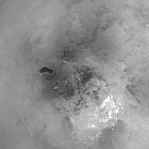
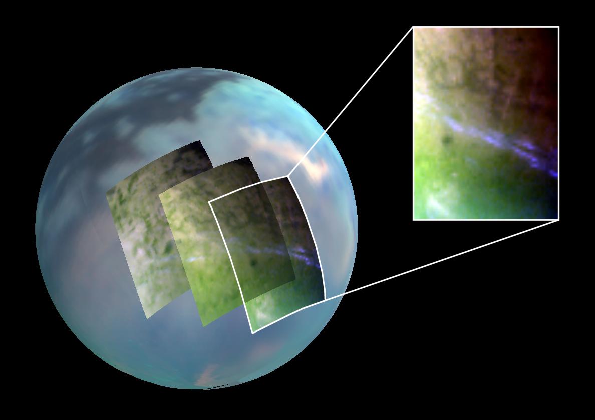
An infrared image of Titan's disk obtained on July 8, 2009 by the Visual and Infrared Mapping Spectrometer of the Cassini probe during the 59th flyby of Titan unveils the first glint of sunlight reflected off a body of liquid.
The view of the crescent of Saturn's largest moon was acquired at a distance of approximately 200,000 kilometers or 125,000 miles at a wavelength of five microns.
The flash of sunlight or the specular reflection was first identified by Katrin Stephan, from the German Aerospace Center (Deutsches Zentrum für Luft-und Raumfahrt or DLR) in Berlin, on July 10th during the phase of image processing.
The glint which implies a sunlight reflection on a mirror-like surface or a smooth area appears to be located around 71 degrees north latitude and 337 degrees west longitude. The reflection took shape in a particular area: the location of the glint coincides with the southern shoreline of what is probably the largest pool of liquids on the Orange Moon, in the high latitudes of the northern hemisphere.
This radar-dark patch known as Kraken Mare is approximately 400,000 square kilometers or 150,000 square miles, that is larger than the largest lake on our planet, the Caspian Sea. As a result, one can reasonably call it a sea rather than a big lake.
The glint of sunlight presents the characteristics produced from a lake or a sea. The human eye can't see the surface from outerspace because Titan's hazy, opaque and deep atmosphere reflects or scatters most wavelengths of solar radiations including the visible wavelengths. However, in the infrared and near-infrared spectrum, some details of Titan's surface and topography can be observed and the glint clearly appeared in the 5-micron wavelength.
Scientists compared the infrared view to radar and near-infrared light portions captured from 2006 to 2008 in order to determine where the specular reflection took shape and to study the nature and topography of the area.
The global view showing the high-latitude flash was taken at the end of the northern winter, as the spring equinox of August 2009 was approaching. The north polar region had been veiled in winter darkness and the area was starting to be illuminated by sunlight. That's why specular reflections in the north polar region hadn't been identified from the VIMS before.
Bob Pappalardo, Cassini project scientist, of NASA's Jet Propulsion Laboratory, Pasadena, California points out:"This one image communicates so much about Titan, thick atmosphere, surface lakes and an otherworldliness."..."It's an unsetting combination of strangeness yet similarity to Earth. This picture is one of Cassini's iconic images.
Katrin Stephan from the DLR in Berlin, who is also an associate member of the Cassini VIMS team showed her surprise and wonder:"I was instantly excited because the glint reminded me of an image of our own planet taken from orbit around Earth, showing a reflection of sunlight on an ocean." She added:"But we also had to do more work to make sure the glint we were seeing wasn't lightning or an erupting volcano."
Prof Ralf Jaumann from DLR's Institute of Planetary Exploration and his collaborator Katrin Stephan argue:"We are confident that these reflections come from a standing body of liquid." Dr Katrin Stephan points out:"We think that in nature only the surface of a liquid can appear so smooth." And Prof Ralf Jaumann explains:"An icy surface -even though it might be mirror-like after freezing- will become rougher from erosion and the grinding effect of tiny particles, or the deposition of atmospheric constituents."
Dr Katrin Stephan advances:"Analysis of the VIMS data strongly suggest that this feature is specularly reflected sunlight from a liquid surface that is smooth on a five micron scale."
This five micron wavelength is part of the atmospheric windows on the Orange Moon, that is wavelengths at which solar radiations can penetrate into the opaque and dense atmosphere of the moon without being reflected or scattered by atmospheric particles. Thus, one can detect, in the 5 micron wavelength spectrum, sunlight radiations which go through the atmosphere and are reflected by Titan's soil toward outer space.
This flash of sunlight or specular reflection in the area of Kraken Mare was made possible thanks to a particular viewing geometry, a particular angle of illumination from the Sun, and particular surface properties.
Ralf Jaumann, head of the DLR Cassini group, notes:"As VIMS observed the specular reflection just at the bright/dark boundary seen in the radar image acquired in 2006, the observation confirms the shoreline of Kraken Mare has been stable for the last three years, and the observation also suggests that the entire Kraken Mare basin is filled with liquid."
He concluded:"These results remind us how unique Titan is in the solar system."..."But they also show us that liquid has a universal power to shape geological surfaces in the same way, no matter what the liquid is."
The lakes, seas and rivers on Titan are likely made of hydrocarbons, primarily ethane and methane. In Titan's environmental conditions, methane and ethane can form liquids because the surface temperature is around -179 degrees Celsius, -290 degrees Fahrenheit or 94 Kelvin and the atmospheric pressure on the surface is around 1467 hPa.
The RADAR and VIMS images have revealed that the pools of liquids tend to be concentrated in the high latitudes of each hemisphere. The largest body of liquid in the south polar region is "Ontario Lacus", a 235 km-wide lake primarily made of ethane and the largest pools of liquid in the north polar region appear to be Kraken Mare, Ligeia Mare and Punga Mare.
A myriad of branching networks and drainage channels have also been spotted in that area, strengthening the belief that the radar-dark patches are authentic lakes or seas. Cloud formations have also been clearly identified in the north polar region and in the south polar region suggesting a strong meteorological cycle involving methane and ethane with evaporation and precipitation phenomena similar to those on Earth.
One of the great challenges will be to figure out why the liquid bodies are more abundant in the north polar region than in the south polar region. Is the dichotomy linked to seasonal factors, orbital parameters, geological parameters or gravitational factors?
A project involving a probe acting as a boat to explore Ligeia Mare, one of the great seas in the north polar region has been under study for about two years. It is called TIME or Titan Mare Explorer and its cost may be in the low $400 m range. That's well below the cost of the Cassini/Huygens mission.
The probe could be launched as early as January 2016 and would reach the Saturnian moon for a plunge in June 2023. The main goals will be to determine the exact composition of the lake or sea, to get images of the surface and to study the meteorological cycle of hydrocarbons.
Dr Ellen Stofan, from Proxemy Research, who leads the study team points out: "The key instrument is a mass spectrometer because you want to know what the lake is made of, but we also want to do things like depth-sounding."
The spacecraft would incorporate an ASRG or Advanced Stirling Radioisotope Generator, which corresponds to a plutonium-driven device that generates power far more efficiently than the usual Radioisotope Thermoelectric Generators (RTGs) used for the Cassini/Huygens mission. A direct-to-Earth communications system would be possible and the generators could sustain several years of operations on the lake surface. And new surprises or findings may come from this "Earth-like moon".
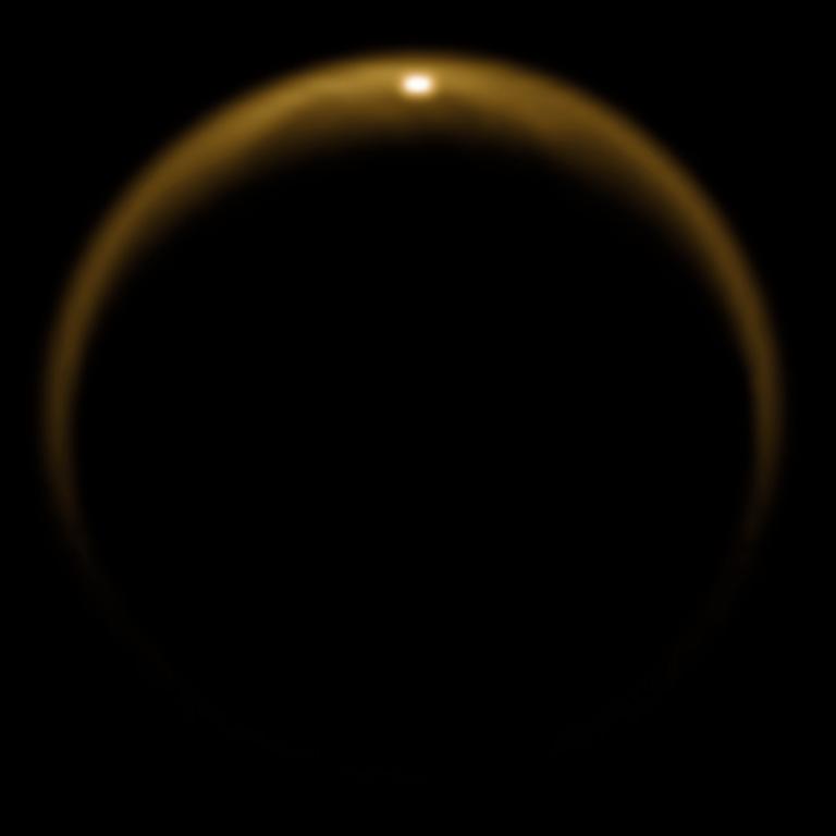
The infrared image of Titan's disk above, obtained on July 8, 2009 by the VIMS of the Cassini probe during the 59th flyby of the moon, reveals the first glint from a pool of liquids in Titan's north polar region, in the area of Kraken Mare, undoubtedly the largest body of liquid on Saturn's largest moon. The view was captured at a distance of about 200,000 kilometers or 120,000 miles. The image was generated using radiation wavelengths in the 5 micron range and the image processing was performed at the German Aerospace Center in Berlin and in the University of Arizona in Tucson. Image Credit: NASA/JPL/University of Arizona/DLR
- To get more information on that news, go to: http://saturn.jpl.nasa.gov/news/newsreleases/newsrelease20091217, http://www.dlr.de/rd/en/desktopdefault.aspx/tabid-2091/5929_read-21728 or http://news.bbc.co.uk/2/hi/science/nature/8409052.stm.
December 7, 2009: The Relative Abundance of Lakes in the North Polar Region Compared to the South Polar Region May Be Related to the Orbital Eccentricity of Titan
The in-depth study of Titan's geology and climate from the data transmitted by the Cassini probe since its arrival in the Saturn System on June 2004 has allowed scientists to determine that the bodies of liquids, made of hydrocarbons (primarily methane and ethane), are concentrated in the high latitudes of Saturn's largest moon.
The Orange Moon, Titan, is not the "Ocean Moon" that some scientists or speculators had imagined: there is no methane ocean in this frozen world at the present time. Nevertheless, there are lakes and seas which turn out to be, surprisingly, concentrated in the high latitudes of each hemisphere. The pools of liquids tend to appear uniformly dark in the near-infrared and RADAR images obtained from the icy moon.
"Ontario Lacus", a 235-km wide pool (primarily composed of ethane and methane), was the first pool of liquids spotted on Titan. It is situated in a topographic depression in the high latitudes of the southern hemisphere.
The equatorial or tropical regions which appear mostly dark in the near-infrared and RADAR images seem to be relatively dry places dominated by Seif dunes or longitudinal dunes shaped by prevailing winds.
The most humid area seems to be located in the high latitudes of the northern hemisphere. The Synthetic Aperture Radar imaging data clearly reveal a multitude of lakes and seas in the "Arctic region" of Titan. Kraken Mare and Ligeia Mare, two significant pools of liquids, are big enough to be regarded as seas instead of lakes. The size of Kraken Mare is roughly similar to that of the Caspian Sea on our "Blue Planet".
Finally, it turns out that there is a surprising dichotomy between the south polar region and the north polar region: there is a strong asymmetry in the amount of liquids or in the surface covered with lakes or seas between the high latitudes of the northern hemisphere and the high latitudes of the southern hemisphere.
How to explain this imbalance? Until now, the dominating hypothesis was the seasonal hypothesis. The radar data unveiled a relative abundance of lakes and seas in the north polar region mainly because the area was running through the winter period when the radar images were taken. Indeed, this seasonal configuration is likely to favour condensation of methane or ethane and rain. Moreover, the area receives less UV light that tends to break up hydrocarbon molecules like methane or ethane in Titan's atmosphere.
The northern hemisphere has run through winter for the last 7 Earth years which corresponds to a season on Titan where a year represents roughly 29.5 Terrestrial years. In parallel, the southern hemisphere was in the summer period which is likely to favour the evaporation of methane and ethane due to the relatively intense radiative flux from the Sun reaching the lakes or seas.
However, the seasonal redistribution movement of volatile hydrocarbons between the poles may be insufficient to account for the current asymmetry in the amount, the volume and the distribution of lakes and seas between both polar regions.
The polar areas have not been completely scanned by the radar mapper but the Synthetic Aperture Radar data already show that lakes and seas in the high latitudes of the northern hemisphere cover 20 times more area than the bodies of liquids in the high latitudes of the southern hemisphere. Furthermore, one can notice that the north polar region has about three times as many dried-up lake basins as the south and seven times as many partially filled pools. As a result, it's clear that the asymmetry is strong and intriguing.
Let's note that the empty lakes or basins or partially filled basins are not always easy to identify: they tend to appear bright or less dark than filled lakes, they appear less smooth than liquid portions and they show topographic rims of the ancient lake.
A new theory is emerging to explain the strong asymmetry in the distribution of surface liquids between the "Arctic" and the "Antarctic" of the Orange Moon. This theory which puts forward the influence of the orbital eccentricity of the Saturn System is presented by Oded Aharonson of Caltech, A.G. Hayes, J.I. Lunine, R.D. Lorenz, M.D. Allison and C. Elachi. The theory is described in a paper appearing in the November 29 advance online edition of Nature Geoscience. The study is entitled "An asymmetric distribution of lakes on Titan as a possible consequence of orbital forcing."
Oded Aharonson focused his attention on orbital parameters instead of parameters regarding the properties of the soil in both hemispheres or differences in terms of geologic activity or topography. He pointed out that initially, specialists had considered the possibility that "there is something inherently different about the northern polar region versus the south in terms of topography, such that liquid rains, drains or infiltrates the ground more in one hemisphere." Yet, the observations don't confirm major topographic or geologic differences between the north and the south polar regions of the moon.
The current regional dichotomy in the distribution of liquid bodies between the north polar region and the south polar region could be, at first sight, explained by seasonal effects since the northern hemisphere has just gone through the winter season while the southern hemisphere was going through the summer season, as we've said.
The winter hemisphere may favour condensation of methane and ethane, the development of cloud formations, rainfall, lakes , seas and rivers while the southern hemisphere may undergo evaporation processes of hydrocarbons resulting in dried-up lakes, seas or rivers.
However, Oded Aharonson argues that the seasonal effects only account for drops of about one meter per year in the depths of pools of liquids in the summer hemisphere. That implies that the seasonal hypothesis is weak and insufficient because the lakes of the Orange Moon are, on average, a few hundred meters deep and wouldn't drain (or fill) in just 15 years, from winter to summer or from summer to winter.
Moreover, paradoxically, the north polar region hosts more dried-up lakes than the south polar region does. The south polar region should host more dried-up lakes, simply because it has just experienced the "warm season" in which the evaporation processes are supposed to be strong. Therefore, Oded Aharonson advanced: "The seasonal mechanism may be responsible for part of the global transport of liquid methane, but it's not the whole story."
Oded Aharonson and his colleagues put forward a new hypothesis to account for the disparity of liquid bodies between the north polar region and the south polar region: the key factor may be related to the eccentricity of the elliptical and oblique orbit of Saturn and Titan around the Sun. The orbit of Saturn, Titan and the other satellites around the Sun is not perfectly circular. Thus, during its southern summer, the Orange Moon is roughly 12 percent closer to the Sun than during the northern summer. It turns out that northern summers are long and mild and southern summers are short and warmer.
Oded Aharonson points out: "We propose that, in this orbital configuration, the difference between evaporation and precipitation is not equal in opposite seasons, which means there is a net transport of methane from south to north." It results in an imbalance in the distribution of pools of liquids between the polar regions of both hemispheres, methane and ethane accumulating in the north polar region and filling topographic depressions.
Like the Earth, it appears that the climate of Saturn's largest moon is driven by Milankovitch cycles by which the long-term changes in the orbital parameters ( eccentricity, obliquity, perihelion precession...) influence Titan's climate and the regional distribution of lakes and seas between the southern hemisphere and the northern hemisphere.
Over very long time scales of tens of thousands of years, the orbital configuration changes and the northern summer is farther from the Sun in certain climatic periods and closer to the Sun in other climatic periods. In parallel, southern summers are farther away in certain climatic periods while the northern summer is closer. Thus, the net transport of methane between hemispheres can be reversed depending on the orbital configuration of the climatic period.
The southern hemisphere is expected to host more lakes when northern summers are aligned with perihelion. That was the case 32 kyr ago: the summer in the northern hemisphere was shorter and more intense because the solar flux or the incident solar radiation (insolation) was higher at that time. Lakes or seas in the north polar region were probably less abundant.
Oded Aharonson argued: "Like Earth, Titan has tens-of-thousands-of-year variations in climate driven by orbital motions." He pointed out: "On Titan, there are long-term climate cycles in the global movement of methane that make lakes and carve lake basins. In both cases we find a record of the process embedded in the geology." He concluded: "We may have found an example of long-term climate change, analogous to Milankovitch climate cycles on Earth, on another object in the solar system."
Marc Lafferre, a specialist of Titan, notes that several factors are likely to have a strong impact on climate and seasonal variations. The obliquity or the tilt of the rotation axis of Titan is relatively high which favours seasonal variations. The obliquity is currently at 26.73 degrees, which is higher than that of the Earth (23.44 degrees). The eccentricity of Titan is, at the present time, 0.055723219 which is higher than that of the Earth (about 0.017).
A high eccentricity is likely to have significant effects on seasonal variations and regional climate. When Titan approaches the Sun, it accelerates which implies that the season for each hemisphere will be shorter and more intense. The moon slows down when it goes away from the Sun which implies that the season of each hemisphere will be longer and less intense.
When Saturn is at aphelion, 1,513,325,783 km away from the Sun, the solar radiation reaching Titan's atmosphere represents roughly 13.5 watts/m². When Saturn is at perihelion, 1,353,572,956 km away from the Sun, the amount of solar energy reaching Titan's atmosphere culminates at about 16.88 watts/m².
One can sum up, as Marc Lafferre advances, that at aphelion, the Saturn system is roughly 11.80% farther from the Sun and receives about 20.02% less solar energy than at perihelion. However, the evolution of temperatures on Titan's surface are not expected to be of that order because of the non-linearity of the Stefan-Boltzmann Law. One can notice that the evolution of the solar irradiation is proportionally higher than that of the Earth between aphelion and perihelion. On can reasonably expect a 5-degree (Kelvin) difference in environmental temperatures between aphelion and perihelion.
Besides, it's important to keep in mind that many other factors are likely to play a key-role in the distribution of lakes and seas on Titan. One can mention the geological phenomena such as cryovolcanoes or geysers which are likely to undergo the influence of varying gravitational effects or tidal forces from Saturn, the other moons and the Sun.
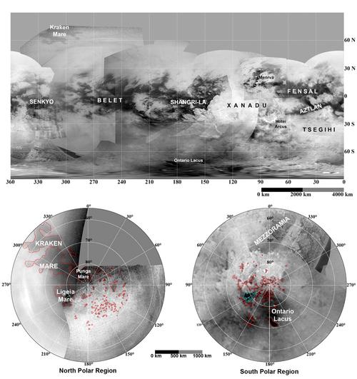
The mosaic above shows a global map of the moon, unveiling the polar lakes and seas of the northern and the southern hemisphere. The two circular views in the lower portion of the mosaic emphasize the liquid pools appearing in the high latitudes of Saturn's largest moon. The lower left view is a north polar projection revealing latitudes 55 degrees to 90 degrees. The lower right map is a south polar projection showing latitudes minus 55 degrees to minus 90 degrees. The maps were performed on the basis of images dating from April 2004 through August 2008. It appears that the pools of liquid are largely more abundant in the north polar region than in the south polar region and Kraken Mare, situated in the northern hemisphere, is probably the largest surface reservoir of hydrocarbons (primarily ethane and methane) on the Orange Moon. Image Credit: NASA/JPL/Space Science Institute
- To get more information on that news, go to: http://saturn.jpl.nasa.gov/news/newsreleases/newsrelease20091130/, http://www.gps.caltech.edu/~oa/titanlakes.shtml, http://www.nature.com/ngeo/journal/v2/n12/full/ngeo698.html and http://www.universetoday.com/2009/11/30/lake-asymmetry-on-titan-explained.
October 15, 2009: Cassini Radar Images of Titan's South Polar Region Reveal Disappearing or Receding Lakes: Seasonal Change?
The south polar region of Saturn's largest moon, Titan, known to harbour "Ontario Lacus", the first pool of liquid clearly identified on Titan, turns out to be a dynamic location, undergoing the effects of changing seasons.
Several radar images of the same areas, captured at different times show that some radar-dark patches associated with lakes of hydrocarbons have disappeared or receded over the course of one to several Terrestrial years.
Two related studies of the finding are presented by Alex Hayes, of the California Institute of Technology and Doctor Jonathan Lunine of the University of Rome Tor Vergata, at the American Astronomical Society meeting in Fajardo, Puerto Rico.
Radar views of the Orange Moon notably show that the bodies of liquids are concentrated in the high latitudes of Titan and that the north polar region is currently more humid than the south polar region. Some seas and a myriad of lakes have been identified in the high latitudes of the northern hemisphere. In the south polar region, only Ontario Lacus can be reasonably compared to the "Great Seas" of the north polar region such as Kraken Mare or Ligeia Mare. And the recent radar image of Ontario Lacus unveils that it has receded or shrunk.
Specialists hypothesize that the disappearance of lakes or the decrease in their level may be explained by seasonal changes in the south polar area. The summer season, in the southern hemisphere, which started, which started in November 2002 came to an end in August 2009 with the Vernal Equinox. By contrast, during that period, the northern hemisphere was running through the winter season.
Thus, the hydrocarbons may condense and form lakes or seas in the colder areas and evaporate in the warmer areas. That would account for the current shift in the distribution of lakes and seas between the high latitudes of the north and the high latitudes of the south.
Source: Division for Planetary Sciences, American Astronomical Society
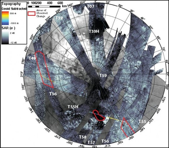
This stereographic projection of Titan's south polar region consisting of Synthetic Aperture Radar portions, obtained between September 2005 and July 2009 shows the locations where lakes have disappeared or receded. The radar changes between observations of the same places are outlined in red. The radar instrument has unveiled 60% of this area and 9% has been scanned by the radar at least twice.
Source: Division
for Planetary Sciences, American Astronomical Society
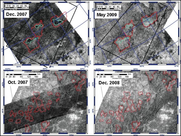
This set of radar images of the south polar region emphasizes the pools of liquids which have dried up, disappeared or receded between observations of the same areas. The bodies of liquid appear as dark patches. They show a particularly low radar return. The two views in the upper part of the mosaic are situated near 60 degrees south latitude, 210 degrees west longitude and were acquired in December 2007 and May 2009.
Landscape features corresponding to empty or dried out lakes are outlined in red. Pools or basins containing liquids in the December 2007 view are outlined in cyan. Those lakes seem to have completely evaporated in the radar view of May 2009. The radar portions in the lower part of the mosaic are located near 69 degrees south latitude, 90 degrees west longitude. The bottom-left view was captured in October 2007 and the bottom-right view was obtained in December 2008.
The radar view of October 2007 shows dark patches in lake beds which appear to have partially evaporated. The topographic features corresponding to the pools are outlined in red. The dark patches reveal the radar signature of liquid bodies. The radar portion of the same area in December 2008 suggests that the assumed lakes have completely or almost completely dried out or evaporated. The dark patches of the October 2007 view don't appear anymore.
Thus, the pools of liquid in the south polar region appear ephemeral , transient. The seasons are likely to play a key role in the dynamics of the high-latitude lakes and the warm season may have a strong impact on the evaporation process of the bodies of liquid: the higher the temperature, the stronger the evaporation process will be. Two-layer models of radar return imply that transport fluxes are about 1 meter of liquid per Earth year.
We know, now, that the level of "Ontario Lacus", a 235 km-wide lake (146 miles) in the south polar region is not static. It varies over time. Between July 2004 and July 2009, the shorelines or the rims of the lake have receded which suggests that the pool is undergoing the process of evaporation or that infiltration occurs throughout the lake crust.
Cassini scientists can, now, base their analysis of Ontario Lacus on several sources of data: they can use infrared or near-infrared data unveiling the global shape of the dark patch which has a shape reminiscent of a kidney. They obtained altimetric data of the lake in December 2008, as well. And in June and July 2009, the RADAR of the Cassini probe obtained its first high-resolution SAR views of the lake.
Altimetric data enable scientists to estimate shoreline topography and calculate the volume of removed liquid. This set of data is also a strong basis for determining the composition of the lake via the imaginary component of the complex index of refraction (k) which indicates the depth to which radar signals can penetrate. One can observe, particularly, that in a direction perpendicular to the shoreline of Ontario Lacus, the radar return or the brightness level decreases exponentially. Hence, one can infer that the lake is in a topographic depression and that the lake is getting deeper as you run away from the coast of Ontario Lacus.
The value of k can be estimated on the basis of topographic characteristics of local slopes. As a result, one must obtain data regarding local slopes. Altimetry outcome is combined with SAR data to calculate k for this specific body of liquid. The value of k obtained is k= (5+/-1)*10^-4. That corresponds to the first empirical estimate of the complex dielectric properties of liquid hydrocarbon on the basis of topographic measurements. The laboratory measurements suggest that the liquid is made of natural gas. Let's insist, however, that the exact composition is not known yet. Accurate laboratory experiments are to be performed.
The volatile character of lakes or seas is most likely associated with a relatively strong evaporation process. Nevertheless, alternative hypotheses are put forward to explain this strong dynamics. A freezing process may have occured between the observations, especially if the liquid contained in the lake represents a cryolava, resulting, by definition, from geysers or cryovolcanoes. The lakes may have receded or disappeared due to subsurface infiltration, as well.
The freezing phenomenon is unlikely because the south polar region was in the summer season when the radar observations were performed. The incoming solar radiations were probably too strong for any freezing process to occur. The cryovolcanic hypothesis is unlikely, as well, because no topographic features, in that area, have been identified as potential ice volcanoes, calderas or geysers.
The infiltration hypothesis draws our attention: one can assume the presence of a porous surface and an absorbing soil with a network of subsurface rivers, lakes, seas or even oceans. Thus, infiltration into a dynamic hydrologic system with a regionally varying methane/ethane table can be reasonably postulated.
The evaporation scenario remains, however, the strongest hypothesis. If the changes in the lake level are fully linked to evaporation, one can estimate evaporation rates of about 1m/yr, consistent with current GCM estimates of methane evaporation rates for the latitudes and seasons in which the observations were carried out.
The Cassini data of the north polar region and the south polar region are starting to show the dynamism of Titan's meteorology and climate. The transport or the movement of methane or ethane clouds between the north polar region and the south polar region seems to be closely linked to seasons which last approximately 7 years. The Titan year lasts about 29 years. Most scientists expect a wetter south polar region in the coming years as the southern hemisphere is running toward the winter season.
It's likely that the volatile hydrocarbons will tend to concentrate in the south polar region and that a transfer of volatile hydrocarbons from the north polar region to the southern hemisphere and the south polar region will progressively take shape. The lakes of the north polar region may progressively dry out until the summer season comes to an end in the north polar region. The Summer Solstice in the northern hemisphere will occur in May 2017. In parallel, the lakes of the south polar region may have significantly grown and some scientists predict that the dark area of Mezzoramia may become the equivalent of Kraken Mare in the high latitudes of the northern hemisphere, that is the big sea of the southern hemisphere.
In the transfer process of methane or ethane from the north polar region to the south polar region, the tropical or equatorial latitudes of the Orange Moon, may receive some methane or ethane rain so that lakes or rivers could take shape in the Huygens landing site. The Huygens probe may be turned into a wreck if rivers or seas take shape in the areas of Adiri and Shangri-La.
The cycle of hydrocarbons between the soil and the atmosphere is far from being clearly understood. Some clouds of methane or ethane appear in a dense atmosphere composed of multiple haze layers. And the interactions between the soil and this haze are unclear. The action of Ultraviolet light on the haze and other compounds of the Titanian atmosphere engenders, throughout the process of photochemistry, new molecules including complex hydrocarbon molecules such as polyynes or polyacetylenes. Polyynes are organic molecules made of alternating single and triple bonds between carbon atoms.
Diacetylene (HCCCCH) and triacetylene (HCCCCCCH) can be found, in particular, in the atmosphere and they represent important constituents of the visible haze layers on the Orange Moon. Polyacetylene are believed to act as an UV radiation shield and a prebiotic ozone.
A combined experimental, theoretical, and modeling research on the synthesis of the polyyne triacetylene shows that it can be generated by a single collision of the ethynyl radical (CCH) and diacetylene (bimolecular gas phase reaction of the CCH with HCCCCH). An ethynyl radical is generated in the atmosphere by the photodissociation of acetylene by ultraviolet radiation. The work was presented by R.I. Kaiser, X. Gu, Y.S. Kim, A.M. Mebel, M.C. Liang and Y.L. Yung. Triacetylene may play a key role in forming more complex and longer polyynes such as tetraacetylene (HCCCCCCCCH) fueling the haze surrounding the moon.
Scientists look forward to exploring and studying the lakes and seas of Titan. One of the projects includes a nuclear-powered lander that would act as an exploration boat in a lake or sea of Titan. Ellen Stofan, a geologist with Proxemy Research in Maryland, is studying the option of that kind of probe. The probe may use the Advanced Stirling Radioisotope Generators (ASRGs) for use on the Discovery missions which have been recently approved by NASA.
- To get more information on that news, go to: http://dps.aas.org/press/2009/Hayes_Titan_Seasonal_Changes_6_October_2009.txt, http://www.universetoday.com/2009/10/06/new-evidence-of-seasonal-change-on-titan, http://www.saturndaily.com/reports/UH_Manoa_Team_Unravels_The_Chemistry_Of_Titan_Hazy_Atmosphere_999.html, http://www.pnas.org/content/106/38/16078.short and http://www.space.com/businesstechnology/091014-titan-boat-mission.html.
September 10, 2009: Where are the Waves of Ontario Lacus?: A New Study suggests the Lake appears to be Extremely Flat
Prior to the arrival of the Cassini/Huygens probe at Saturn in mid-2004, scientists suspected the presence of lakes, seas or even oceans of hydrocarbons on Saturn's largest moon, Titan. Yet, the images taken from the Huygens probe during its plunge into Titan's atmosphere on January 14, 2005 revealed that the area where it landed, close to the equator, was not covered with seas of methane or ethane in that period of the Titan year.
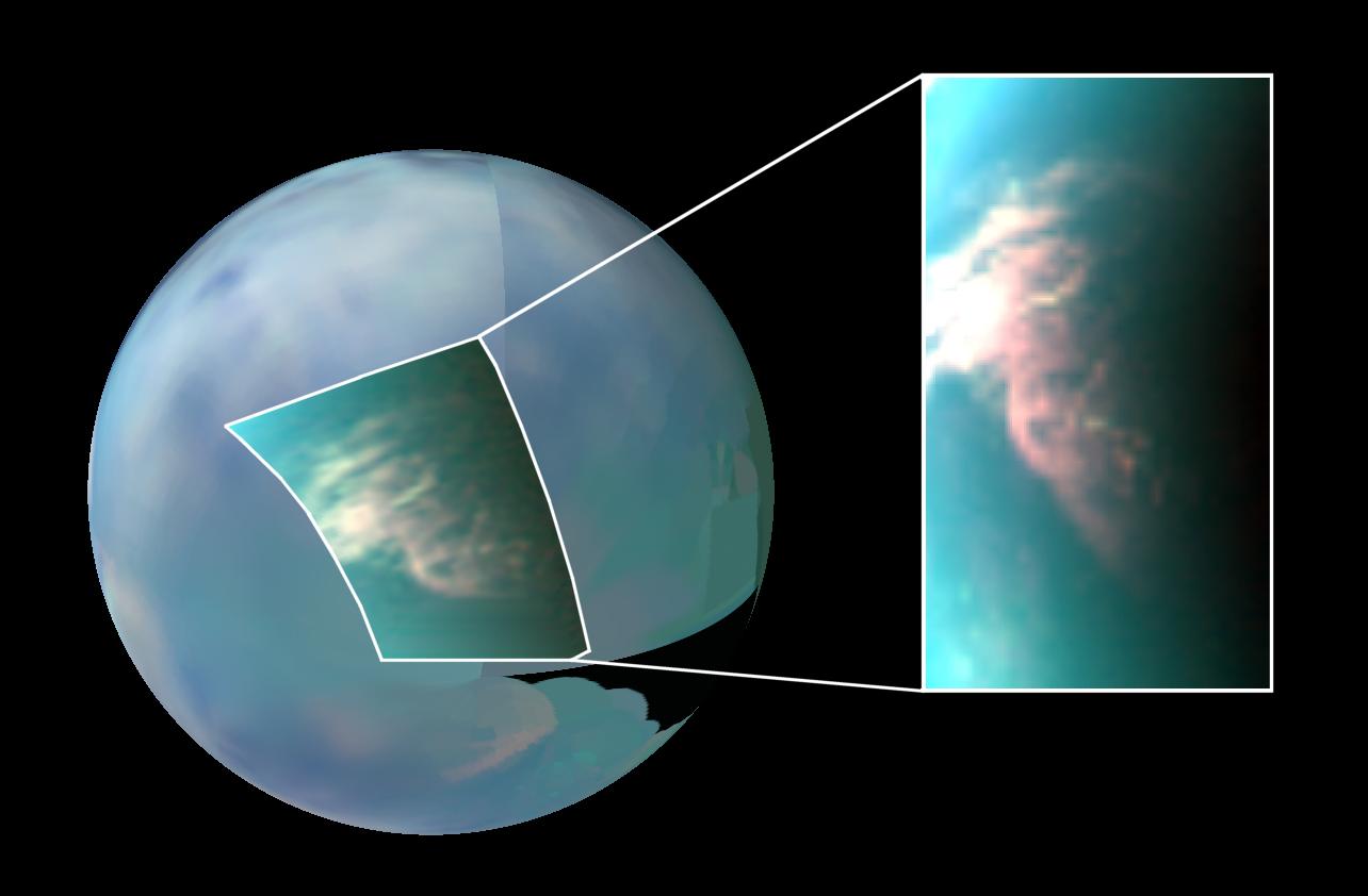
However, subsequent images from the Cassini probe acquired with the Visual and Infrared Mapping Spectrometer or the radar mapper allowed scientists to determine that pools of liquids were concentrated in the polar regions of the moon. And the first significant clue for an extraterrestrial lake or sea was obtained in 2005 with the discovery of a uniform, dark patch in Titan's south polar region. This kidney-shaped feature is, now, known as "Ontario Lacus". This low-albedo feature, which was acquired in the infrared spectrum with the VIMS onboard the Cassini spacecraft, is about 235 kilometers (146 miles) across. The southern hemisphere of the Orange Moon was in the summer season when this uniform patch was spotted.
Later, radar data from the Cassini spacecraft unveiled a myriad of lakes and seas in the north polar region, plunged into the winter season. The finding of significant, dynamic cloud systems in the high latitudes of the southern hemisphere is consistent with the idea of an hydrocarbon cycle with lakes, seas, rivers, evaporation processes, cloud development and rain.
A new study presented by L.C. Wye, H.A. Zebker (Department of Electrical Engineering, Standford University, Stanford, California) and R.D. Lorenz (Space Department, Johns Hopkins University Applied Physics Laboratory, Laurel, Maryland) suggests that Ontario Lacus, located at about 183 degrees west, 72 degrees south, is extremely smooth or flat. It seems unbelievable but this uniform patch appears as smooth as a mirror, varying in height by less than 3 millimeters.
This outcome was obtained thanks to the RADAR altimetry data collected on the 49th flyby of Saturn's largest moon on December 21, 2008 with the radar instrument which scanned Ontario Lacus. The height variations are based on the 100m-wide Fresnel zone which runs through Ontario Lacus. The radar echo of the area covering thousands of square metres was higher than expected and it severely saturated the receiver. As a result, the team was forced to design a method to partially correct the echoes for the distortion engendered.
Lauren Wye explained: "It's like if you had a flashlight and you shined it straight down at a mirror, and it blinds you when you look down at it." The surface appears 10 times as flat as previous measurements were able to unveil. Lauren Wye said: "It's very hard to imagine a solid surface that is smooth on the order of millimetres." Howard Zebker argued: "Unless you actually poured concrete and spread it really, really smoothly, you'd never see something like that on Earth."
Spectroscopic data obtained with the VIMS in December 2007 showed that at least a thin layer of liquid made of ethane was present at Ontario Lacus. Most scientists believe that the body of liquids is filled with mixtures of ethane and methane.
The smoothness of the lake contradicts earlier computer simulations (from Dr Nadeem Ghafoor of Surrey Satellite Technology, Professor John Zarnecki of the Open University, Dr Meric Srokecz and Dr Peter Challenor of the Southampton Oceanography Centre) which had shown that waves would be seven times as high and long as those on our planet.
Indeed, the main physical data in Titan's environment are radically different from those on Earth: the gravity is weaker than the gravity of our moon, that is 7 times weaker than that on Earth and the atmospheric pressure at surface level is higher than on Earth at about 1.5 bar. And the winds are expected to be relatively strong in the equatorial region of Titan. Are they strong in the south polar region? The smoothness of the lake implies an unusually quiet wind.
The nature of the contents of Ontario Lacus is unclear but the exceptional smoothness of the body could suggest that the liquid or the material is thick and viscous, like honey. The smoothness may not be associated with dried mud or soot as Zebker notes. He advanced: "If you've ever walked outside and seen an area on the ground where there's mud and the water dries up, even that is pretty flat - but you get cracks in the mud and pieces that curl up." He claimed: "You never see anything as smooth as what we're inferring for Titan's surface."
This extremely smooth lake may be a funny place for skipping rocks if future explorers manage to land in that area. Howard Zebker pointed out: "In this one particular lake, the largest lake on Titan and therefore likely to be the roughest , we see no evidence whatsoever of big waves. You could skip rocks really well."
As the summer season is coming to an end in the southern hemisphere, the area of Ontario Lacus seems exceptionally calm. Is it a meteorological paradox? Jonathan Lunine of the University of Arizona advanced: "This is the time of the year that we would expect the polar regions to be quiescent." And he added: "I think Ontario is filled with liquid... Liquid is the simplest, most consistent explanation for all the data sets."
The T49 flyby, which occured on December 21st, 2008, allowed scientists to gather precious data upon the shape of Ontario Lacus via the radar altimeter. It reveals, in particular, that the smooth lake is located in a 300-meter (around 984 feet) topographic depression. Therefore, the lake is likely particularly deep.
The altimetry data imply that the eastern lake margin turns out to be relatively steep (about 0.3 degrees over 50 km, in the plot) and that the western margin has a relatively gentle ramp (around 0.1 degrees).
The altimetry profile of Ontario Lacus in the groundtrack scanned by the radar altimeter shows that the eastern portion of the lake appears to have some roughness whereas the western portion is remarkably flat or smooth. Those data may be explained by the proximity of the shoreline in the eastern portion of the groundtrack.
The remarkable smoothness of the kidney-shaped lake raises questions related to winds and meteorology in that area as well as questions related to the nature of the liquid. Ethane and methane may be mixed with other compounds such as propane (C3H8). The molecule propane, which was first identified in Titan's atmosphere in 1980 when the Voyager 1 probe flew past the Saturnian system, represents a small fraction of the Titanian atmosphere.
Thanks to data gathered by Cassini's Composite Infrared Spectrometer, from the edge of the atmosphere, between June 2004 and June 2008, the Cassini team was able to provide an estimate of the amount of propane in the orange atmosphere.
Cassini scientist Conor Nixon of the University of Maryland, College Park advanced: "We estimate there are nearly 700 million barrels of propane on Titan... That is enough to fill six-billion 20-pound tanks of liquefied propane gas. It sounds like a huge amount, but that would satisfy total U.S. consumption of propane for only 18 months... Titan's atmospheric inventory would fuel about 150 billion barbecue cookouts, enough for several thousand years of Labor Days."
Marc Lafferre, a specialist of Titan, notes that the amount of propane identified in the atmosphere represents, approximately, 111 291 110 cubic meters, which is almost twice as much as the volume of Lac de Saint-Cassien in Var (France). This amount of propane could fill a lake approximately 2 620 meters wide (about 8 596 feet wide) with a mean depth equivalent to that of Lac de Saint-Cassien ( around 16 meters or 52 feet). This amount of propane also represents nearly 9 days of oil consumption worldwide.
The finding of significant concentrations of propane in the gas blanket of Saturn's largest moon notably raises questions upon the complexity of the organic chemistry on Titan. The action of UV light in the upper atmosphere of the moon is likely to break up hydrocarbon molecules which then recombine to form simple or complex organic molecules. This process is often compared to a "lego game" in which various structures can be assembled. One can assume that the most complex organic molecules will appear on the ground.
Conor Nixon pointed out: "It was not so much that measuring propane was our endgame, but it helps enormously in our hunt for other complex molecules."... "These include pyrimidines that are potential building blocks for biological molecules, such as the nucleobases of our DNA."... "If we can detect them on Titan, that would be very significant."
The surprising, apparent smoothness of Ontario Lacus is consistent with a viscous liquid made of several types of hydrocarbons. And claiming that ethane, methane and propane are the primary components of Ontario Lacus seems relevant. The waves of that kind of liquid in a large pool may resist the action of winds, allowing the lake to appear smooth like a skating-rink or a frozen lake.
This image of Titan's south polar region obtained from the Cassini spacecraft in the infrared spectrum during a Titan pass on June 6, 2005 clearly shows the kidney-shaped lake "Ontario Lacus". Ontario Lacus is the uniform, dark patch in this view. A recent study reveals that this lake is exceptionally smooth. In the lower right of the view, one can notice bright patches which correspond to cloud systems. Credit: NASA/JPL/Space Science Institute
- To get further information on that news, go to: http://www.newscientist.com/article/dn17665-saturn-moons-mirrorsmooth-lake-good-for-skipping-rocks.html, http://www.lpi.usra.edu/meetings/lpsc2009/pdf/1990.pdf, http://www.agu.org/pubs/crossref/2009/2009GL039588.shtml and http://www.saturndaily.com/reports/Saturn_Moon_Could_Power_150_Billion_Labor_Day_Barbecues_999.html.
August 15, 2009: Significant Cloud System identified Over Titan's Tropical Desert
We know, now, that large cloud systems, lakes, rivers or rainfalls take shape, mostly, in the polar regions of Saturn's largest moon Titan. The Huygens probe which landed on January 14, 2005 in Titan's equatorial region at about 10.31 degrees south latitude, 167.61 degrees east longitude in the Adiri area revealed an intriguing landscape with bright hills containing what appeared to be drainage channels. The probe landed far from the hills in what seemed to be a riverbed but no pool of liquid hydrocarbons was spotted. The hypothetical ocean of methane or ethane was not there.
The subsequent observations from the Cassini spacecraft showed that the wet areas were surprisingly located in the high latitudes of Titan. The "Visual and Infrared Mapping Spectrometer" via infrared or near-infrared images revealed Ontario Lacus, a big lake in the south polar region as well as large cloud formations. And the radar mapper of the Cassini spacecraft revealed rivers, lakes or seas in the high latitudes of Titan's northern hemisphere.
The equatorial area turns out to be made of radar-dark regions dominated by dune fields extending over long distances. Thus, some researchers had concluded that the tropics on Titan were a tropical desert receiving low levels of precipitation. Yet, the announcement of a new finding suggests that precipitations in the tropics may be higher than we think. This finding may help us better understand geological features such as Seif Dunes and drainage channels in the low latitudes of the Orange Moon.
A team of US astronomers identified a significant cloud patch within Titan's tropical zone in April 2008 by using the Gemini North telescope and NASA's Infrared Telescope Facility (IRTF) both on Hawaii's Mauna Kea. The finding is presented in a study of the August 13th issue of the journal Nature. The paper proposed by E.L. Schaller, H.G. Roe, T. Schneider and M.E. Brown is entitled "Storms in the tropics of Titan". The large cloud system spotted at low latitudes is roughly three million square kilometers which approximately corresponds to the size of India.
The regular observations of the tropical zone of Titan, prior to the discovery , had shown that the area seemed particularly arid or dry. The team observed the Orange Moon on 138 nights over 2.2 years. The global views, during that period (mid-to-late northern spring season), revealed that cloud cover was well under one percent.
A rupture occured in mid-April of 2008: on April 13, 2008, observations made with the 3.0 meter NASA Infrared Telescope Facility (IRTF) operated by the Institute for Astronomy, University of Hawaii, unveiled a dramatic increase in cloud cover on the disk of Titan. From that stunning discovery, the team used the Gemini North 8.0-meter telescope for many nights to capture quick imaging snapshots of the disk.
It turns out that the initial cloud cover was at 30 degrees south latitude. And in the following days, cloud formations appeared closer to the equator and in the south polar region. Team member Emily Schaller of the University of Hawai'i pointed out: "It was as though we observed a giant storm covering South Africa that days later caused clouds to form over Antarctica and Indonesia."
This interdependence phenomenon between clouds appearing at different locations is known as atmospheric teleconnections. This atmospheric or meteorological process is encountered in the Earth's atmosphere and is triggered by what are known as planetary Rossby waves, a well understood "dynamics".
Team member Henry Roe from Lowell Observatory, Flagstaff, Arizona underlined: "In April 2008 we observed what was a global event that shows how storm activity in one region can trigger clouds, and probably rainfall, over arid regions, such as the tropics where Huygens landed." And he pointed out: "Of course these rain showers are not liquid water like here on Earth, but are instead made of liquid methane. Just like the streambeds and channels that are carved by liquid water on Earth, we see features on Titan that have been created by flowing liquid methane."
The surface temperature on Titan is around -179 degrees Celsius, -290 degrees Fahrenheit or 94 Kelvin and the atmospheric pressure is close to 1.5 Bar. In that environment, water is frozen on the surface and it looks like rocks or boulders. On the other hand, methane or ethane appear as liquids. Thus, the channels are likely carved by liquid hydrocarbons and the clouds are likely composed of methane or ethane.
The finding of the low-latitude cloud system probably brings a significant clue to the puzzle. Weather models had anticipated that Titan's equatorial or tropical zone was arid, dry and that the south polar clouds identified, should have disappeared by mid-to-late summer. Are there internal or geological phenomena responsible for those unexpected cloud systems ?
Emily Schaller who had noticed the significant increase in cloud cover showed that this discovery is the outcome of a long examination led by the team. She explained: "We obtain frequent observations with IRTF giving us a 'weather report' of sorts for Titan. When the IRTF observations indicate that cloud activity has increased, we are able to trigger the next night on the Gemini telescope to determine where on Titan the clouds are located."
The channels or streambeds carved by liquid methane or liquid ethane in the Huygens landing site (or the Hubert Curien area) were thought to be the outcome of uprising of liquid methane or ethane. Now, the finding of significant outbursts or development of cloud formations in the tropics implies that massive rainfalls of methane or ethane are likely to occur in the Adiri region where the Huygens module touched down.
As a result, strong hypotheses emerge regarding the origin of the branched channels in Adiri: they may be drainage channels shaped by rainfall. The cryovolcanism scenario loses some ground. One can also suggest that rainfalls are rare in the tropics and that the evaporation level is relatively high. Infrequent monsoon events or tropical storms in the equatorial region may account for the formation of Sand Seas or dune fields which take the shape of Seif Dunes. The erosional processes from rain may have turned the upper part of the soil into sand grains and prevailing winds may have engendered those patterns of dune fields which extend over long distances along the equator.
Henry Roe advanced: "These observations show that the channels and streambeds in Titan's tropical desert can be explained by infrequent but strong downpours, much like many of the landforms here in the Southwestern United States."
The mechanisms by which those cloud systems form in the low latitudes are not clearly understood. More data are needed over a long period of time because a year on Titan is long. Henry Roe pointed out: "Titan's year is 30 Earth years long and so far we've only been observing Titan with this type of precision and frequency for less than one Titanian season... Imagine trying to understand Earth's weather having only seen what happens in January, February, and part of March. We have our work cut out for us to continue watching the weather on Titan for many more years."
Mike Brown of the California Institute of Technology (Caltech) insisted on the explosive, sudden character of the cloud system and its meteorological consequences. He pointed out: "The first cloud was seen near the tropics and was caused by a still-mysterious process, but it behaved almost like an explosion in the atmosphere, setting off waves that traveled around the planet, triggering their own clouds. Within days a huge cloud system had covered the south pole, and sporadic clouds were seen all the way up to the equator."
The finding from Earth-based telescopes was made possible thanks to adaptive optics technology which incorporates a deformable mirror to remove distortions to light engendered by the Earth's atmosphere.
Besides, some clues gathered from the Cassini spacecraft suggest the presence of cryovolcanoes expelling cold slurries of water-ice and ammonia. The Visual and Infrared Mapping Spectrometer (VIMS) which regularly obtains infrared or near-infrared views of Titan's surface revealed landscape features which may be calderas or volcanic domes.
It also showed a varying infrared signature in Hotei Regio consistent with the temporary presence of ammonia frosts that later dissipated or were covered over. As a result, can ice volcanoes engender clouds such as the massive cloud system found at low latitudes ?
New infrared images of Hotei Regio were presented at the XXVII General Assembly of the International Astronomical Union (IAU) in Rio de Janeiro, Brazil. Robert M. Nelson, a senior research scientist at JPL pointed out: "The images provide further evidence suggesting that cryovolcanism has deposited ammonia onto Titan's surface. It has not escaped our attention that ammonia in association with methane and nitrogen, the principal species of Titan's atmosphere, closely replicates the environment at the time that life first emerged on Earth. One exciting question is whether Titan's chemical processes today support a prebiotic chemistry similar to that under which life evolved on Earth ?"
The infrequent appearance of significant cloud formations in Titan's tropics, that the weather models hadn't predicted, pushes us into thinking that a cryovolcanic eruption may be responsible for this outburst of cloud activity in the tropical desert of Titan.
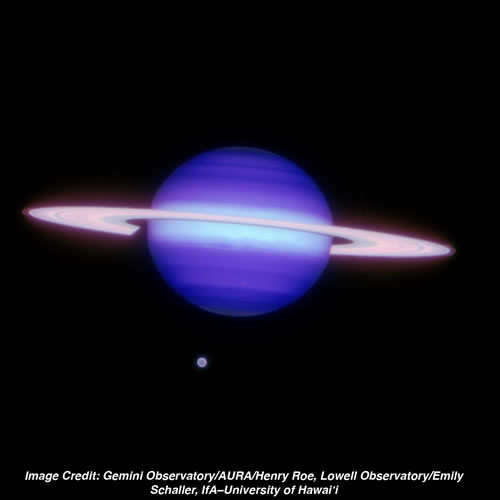
The global view above showing Saturn
and Titan is a Gemini North infrared image
acquired on May 7, 2009. It was obtained using the Altair adaptive optics
system with the Near-infrared imager (NIRI). The field of view is approximately
40 arcseconds across. As usual, Saturn's largest moon appears uniform with
no hint of clouds.
Image Credit: Gemini Observatory/AURA/Henry Roe,
Lowell Observatory/Emily Schaller, IfA-University of Hawai'i

The image of Titan, above, showing the
significant cloud patch at low latitudes was captured
on April 14, 2008 (UTC).
The view of the Orange Moon was acquired with the Gemini North Telescope
using adaptive optics. It is a near-infrared view in the 2.12 micron wavelength.
Titan appears as a disk with an angular diameter of about 0.8 arcsecond
in this view. The bright
patch corresponds to the storm feature in the tropics of the moon.
Image credit: Gemini Observatory/AURA/Henry
Roe, Lowell Observatory/Emily Schaller, Institute for Astronomy, University
of
Hawai'i
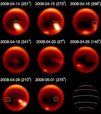
The eight views of
Titan's disk above which were taken at different times in April and
May of 2008 unveil bright patches which correspond to cloud formations.
One can observe, notably, a cloud outburst in the tropics in the view
obtained on April 14, 2008. The other images show the development and
the dynamism of the significant cloud system. A bright patch also appears
in the south polar region.
Image credit: Emily Schaller et al./Gemini
Observatory
- To get further information on that news, go to: http://www.gemini.edu/node/11305, http://www.lowell.edu/media/releases.php, http://media.caltech.edu/press_releases/13282, http://www.astrobio.net/pressrelease/3208/earth-with-a-frigid-twist and http://www.iau.org/public_press/news/detail/iau0915.
July 24, 2009: Some Researchers put forward the Hypothesis of a Silicon-Based Life in Titan's Wet Areas
Saturn's largest moon, Titan, appears to be one of the most fascinating and enigmatic worlds in the Solar System. The Orange satellite is covered with a deep and opaque atmosphere mostly composed of nitrogen and methane (about 1.6% of its composition). The presence of significant amounts of hydrocarbons in Titan's environment is intriguing: scientists wonder how complex the organic chemistry is on the Orange Moon.
The ultraviolet radiations from the Sun play a key role in Titan's stratosphere because they tend to break down hydrocarbon or organic molecules that recombine to form new molecules such as ethylene, acetylene, hydrogen cyanide or more complex organic molecules. So, is there a polymeric chemistry on Titan's surface ? Nobody knows, yet but new data from the Cassini spacecraft suggest that the organic chemistry on the icy moon is likely to grow to a high level of complexity.
Radar and infrared or near-infrared data obtained by the Cassini probe during its journey in the Saturn system have allowed Cassini researchers to determine that Titan's wet areas are concentrated in Titan's polar regions at the present time. Large cloud formations have been, regularly, observed in Titan's south polar region during the summer period of the southern hemisphere. A large body of liquid known as "Ontario Lacus", over 200 km wide, has also been identified in the south polar region.
The north polar region, currently in the winter season with the vernal equinox approaching, appears to be the most humid area with a multitude of lakes or seas such as Kraken Mare or Ligeia Mare. Besides, a large stratospheric ethane cloud is engulfing the north polar region.
Those pools of liquids are believed to consist of mixtures of methane and ethane. The environmental conditions on Titan are suited for the presence of hydrocarbons in their liquid state. The Huygens probe, which landed in the equatorial region, on January 14, 2005, recorded an atmospheric pressure of 1467 hPa on the landing site and an environmental temperature of -179°C (-290°F or 94K). At this temperature, methane, ethane or propane can be found in their liquid state and are likely to form lakes, seas or rivers.
Can pools of liquid hydrocarbons act as a solvent for the development of any form of life ? That's a growing debate among scientists. One of the key elements of life on Earth, that is carbon, is widespread on Titan. However, environmental conditions don't allow the presence of liquid water on the surface. If there is water, it will appear as a solid, as ice. In fact, the soil could be made of water ice or frozen carbon dioxide. So, if there is a lifeform on Titan, it's very unlikely that it will be based on water.
Some scientists speculate that a subsurface ocean made of mixtures of water and ammonia is hidden beneath the icy crust. The high concentration of nitrogen in the moon's atmosphere is consistent with this idea. If this ocean exists, it could represent a good solvent for the development of any autonomous organism.
The presence of surface lakes or seas of hydrocarbons also implies the possibility of the development of a lifeform based on methane since carbon, methane and ethane are found in large quantities.
Tetsuya Tokano, a planetary scientist at the University of Cologne in Germany shows in a paper of the March 2009 issue of the journal Astrobiology that Titan's lakes could represent an "ad hoc" environment, a well suited environment for a certain type of prebiotic-like chemistry that could lead to life. In his study, he shows that the make-up and the volume of the bodies of liquids are likely to play a key role in the development of any prebiotic chemistry. UV and other high energy radiations from the Sun are likely to spark fundamental reactions that generate more complex molecules in the pools of liquids.
Tetsuya Tokano pointed out: "I found that the result is very dependent on the chemical composition of the lakes... If certain chemicals are missing, then the lake could freeze or dry out. But if the lake is composed of a mixture of ethane, methane and nitrogen, the lake can exist for many years and provide a medium for prebiotic-like chemistry."
The radar mapper of the Cassini spacecraft didn't provide any significant information on the physical characteristics of the hydrocarbon lakes or seas. Scientists don't know exactly what they are made of and how deep they are.
Tetsuya Tokano used available data and computer numerical models to study different lake types to identify which are most adapted for the development of any prebiotic chemistry or alien life. The pool of liquids must contain the right ingredients and must have the right volume of liquids. If the pool is too shallow, it might evaporate too soon for any prebiotic chemistry or lifeform to develop or take shape. If the pool is too deep, it might have a lower or bottom layer that is too differenciated from the upper layer so that it doesn't mix well with the upper layer, preventing the right cooking for the development of the complex prebiotic or biological chemistry.
Since we don't know the mechanisms by which life emerged on Earth, most of our hypotheses are based on speculation and what we know of the physical and chemical environment. Tetsuya Tokano advanced: "If there is life on Titan it would be very different from that on Earth... And we don't know if such life is possible at all. It's just speculation."
Some scientists put forward the possibility of a silicon-based life on Saturn's largest moon. Silicon would replace carbon as a building block for any lifeform. Cells would be constructed on the basis of silicon instead of carbon. Silicon-based organisms would use another solvent than water, probably liquid methane, liquid ethane or even liquid ammonia. The exotic lifeforms thriving on Titan would, a fortiori, look and function differently than familiar lifeforms.
Nobody knows if silicon-based beings can emerge and develop in a specific environment. But, it seems that the moon has favourable conditions or ingredients for the development of that exotic lifeform. The temperatures and the gravity at surface level are relatively low and oxygen is almost absent in Titan's atmosphere. Moreover, the Orange Moon lies near the limit of Saturn's magnetic field. Thus, high energy cosmic rays can reach Titan's upper atmosphere and engender complex molecular reactions.
Let's acknowledge, however, that silicon doesn't appear to be as adapted for the development of any lifeform as carbon. Silicon atoms which are much bigger and heavier than carbon elements have difficulty forming double or triple covalent bonds. Bonds between silicon atoms are roughly half as strong as bonds between carbon atoms. Silicon atoms tend to combine with molecular oxygen to form quartz or sands. But the relative lack of oxygen, apparently, in Titan's atmosphere may prevent the trap of silica or SiO2 which is likely to eliminate any possibility of more complex molecules involving the silicon element.
Any lifeform using the cycle O2, SiO2 is not expected on Titan due to this relative lack of O2 in the atmosphere and silicon dioxide would not appear as a gas in the Titanian atmosphere. As a result, we shouldn't encounter exotic, alien organisms breathing SiO2 and expelling O2, or breathing O2 and expelling SiO2 in that cold environment.
Nevertheless, even if this cycle turns out to be technically impossible, one can imagine complex polymers involving silicon and oxygen. Silicones, made of alternating silicon and oxygen atoms, are known to be relatively stable. But can these molecules be biogenic ?
The presence of significant amounts of hydrocarbons in Titan's atmosphere and on its surface implies that molecules made of silicon and hydrogen can take shape (silanes). However, long-chain silanes spontaneously decompose and silanes are highly reactive with water. So, if the hypothetical underground ocean of water and ammonia exists, it's unlikely that molecules made of silicon and hydrogen will reach the "biological level".
Chains of molecules made up, exclusively, of silicon atoms will decompose in contact with water since silicon-oxygen bonds and silicon hydrogen bonds are stronger than silicon-silicon bonds as the astronomer Marshall Perrin noted in 2008 in a paper entitled "Xenobiology At the Extremes: And you Think Your Neighbors Are Weird ?" And silica or silicon dioxide is a non-soluble solid at the thermal range where water is liquid which suggests that no further reactions are expected once silicon atoms capture O2 molecules.
Silicon-based life might emerge, arise under specific conditions of temperatures, pressures and gravity as well as under a specific environmental chemistry. Is Titan a good shelter for that kind of life ? Perhaps ! Some specialists believe in that hypothesis. The idea of a silicon-based life has been theorized.
One can mention the theory of A.G. Cairns-Smith which is related to the early Earth. This researcher who presented his theory in the 80's postulated that the first living organisms on our planet were clay minerals, probably based on silicon. Since the environmental conditions on Titan are believed to be close to the prebiotic conditions of the Early Earth, one could extrapolate that these hypothetical clay minerals exist on Titan.
The finding of lakes and seas, probably made of mixtures of methane, ethane and dissolved molecular nitrogen in the polar regions of the Orange Moon raises the captivating possibility of a methane-based life. A methane cycle has been identified: there are pools of hydrocarbons, there are cloud formations and there are probably rainfalls and snowfalls. Those elements seem to be the right ingredients for the development of a methane-based life which would use the carbon element as on Earth. Marc Lafferre, a specialist of Saturn's largest moon, developed in 2004 a model for a methane-based life on Titan with an ecosystem involving exotic animals and exotic plants. The animals breathe hydrogen and expel methane while plants breathe methane and expel hydrogen. Both animals and plants drink or absorb the ethane-rich liquid which fills lakes and seas.
Dirk Schulze-Makuch and David H. Grinspoon made an in-depth analysis of the potential for a biological system on Titan involving the carbon cycle in a paper entitled "Biologically Enhanced Energy and Carbon Cycling on Titan ?" They note that an environment is likely to lead to the development of life if it allows the formation of a polymeric chemistry, if it hosts energy sources and if it contains pools of liquid solvents in appreciable quantities. The endemic living organisms must adapt to the harsh environment by developing metabolic strategies.
David H. Grinspoon and Dirk Schulze-Makuch point out that two major energy sources are envisaged: the first source is the photochemical action of UV light on hydrocarbons and other molecules in Titan's upper atmosphere (stratosphere). The second source is the potential presence of an active cryovolcanism and geysers resulting from tidal heating and other internal forces (radioactivity, subduction mechanisms...).
In their model, they consider a subsurface ocean consisting of a mixture of ammonia and water undergoing convection movements with typical convection cells. The crust of the moon which floats above the internal ocean is supposed to be composed of water ice, ammonia ice, silicate rocks and liquid hydrocarbons appearing in pore spaces. Geysers or cryovolcanoes expelling the content of the internal ocean take shape. Hydrocarbon lakes mostly composed of ethane fill topographic depressions in the wet areas of Titan where methane clouds appear, generating methane rain.
In Titan's upper atmosphere, a photochemical haze is present, engendered by the action of ultraviolet light from the Sun. Some compounds such as acetylene (C2H2) or hydrogen cyanide (HCN) are produced in this haze. Acetylene will tend to condense and fall to the surface where it will accumulate. Acetylene will be found in the bottom of the hydrocarbon lakes, as well.
David H. Grinspoon and Dirk Schulze-Makuch envisage two key metabolic strategies for any lifeform in Titan's harsh environment. The first metabolic reaction is the catalytic hydrogenation of photochemically produced acetylene. The second process involves the recombination of radicals generated in the atmosphere by ultraviolet radiation.
The catalytic hydrogenation of the energy source, acetylene, produced high in Titan's stratosphere is made possible by the significant concentrations of acetylene and hydrogen in the atmosphere. The metabolic reaction is summarized by: C2H2 + 3H2 --> 2CH4. The metabolic reactions implying recombinations of radicals to yield energy are summarized by: CH2 radical + N2 radical --> CN2H2 and 2CH radical + N2 radical --> 2HCN.
The persistence of relatively high concentrations of methane in Titan's atmosphere could be explained, fully or partly, by the catalytic hydrogenation of photochemically produced acetylene which could act as a replenishment source or recycling source for the atmosphere. Methane is, indeed, unstable and is destroyed, in the atmosphere on a short time scale of approximately 10^7 years by ultraviolet light from the Sun.
Anyway, if life exists on Titan, it is very unlikely that the creatures on the surface will be based on water because water doesn't appear as a solvent on the soil: if there is water on the soil, it will appear as water ice and it will be comparable to our silica on Earth. As a result, the hypothetical lifeform on Titan's soil is more likely based on methane. Marshall Perrin noted in his study that ethane and methane which are nonpolar solvents would have trouble dissolving DNA, proteins and many other compounds.
Some lakes or seas in Titan's north polar region may host the life we're looking for. Can you imagine a sea as big as the "Caspian Sea" with no life inside ? Kraken Mare may be one of those or it may not be one of those.
Titan's lakes and seas draw the whole attention of scientists and a myriad of questions are raised upon those reservoirs of liquids. Tokano advanced: "I don't know the exact color, but a deep lake would be darker than a shallow lake, and perhaps the color is not blue." He pointed out: "I would like to know the depth of the lakes, and the exact chemical composition. In principle, if we have a future mission to Titan, a probe which lands on the lake itself, it should be possible." He concluded: "I you compare the conditions of Earth and Titan, we can maybe find the difference in the evolution of prebiotic chemistry, and discover which conditions are necessary."
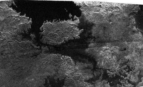
The radar view above captured by Cassini's radar instrument shows the northern part of the sea "Kraken Mare" in Titan's north polar region. This radar portion, centered at approximately 79 degrees north latitude and 310 degrees west longitude, was obtained during the Titan flyby of February 22, 2007. The sea appears uniformly dark. Does it harbor life ?
- To get further information on that news, go to: http://www.astrobio.net/index.php?option=com_exclusive&task=detail&id=3165, http://arxiv.org/ftp/physics/papers/0501/0501068.pdf and http://www.strangehorizons.com/2008/20080825/perrin-c.shtml.
June 9, 2009: Cloud Activity in Titan's Southern Hemisphere shows a Surprising Dynamism at the End of the Summer Season
The Cassini spacecraft, since its arrival at Saturn and Titan in 2004, has allowed scientists to identify large cloud formations in the high latitudes of each hemisphere of the Orange Moon as well as elongated clouds at mid-latitudes. This particular distribution of clouds within the globe is, roughly, consistent with global circulation models proposed by specialists. Cassini scientists have surveyed Titan's atmosphere for three-and-a-half years, between July 2004 and December 2007 and more than 200 clouds were spotted during that period.
The development, the dynamics and the geographic origin of clouds are expected to be strongly linked to seasons. The southern hemisphere of the hazy moon is currently in the summer season whereas the northern hemisphere is in the winter season. The seasons on Titan are particularly long: the moon orbits around the Sun in about 29.5 Terrestrial years and each season lasts around 7 Terrestrial years. The summer season in the southern hemisphere is coming to an end: the vernal equinox will occur in August 2009. The prospect of the change in seasons in the southern hemisphere implies significant, potential changes in the meteorology of the area. Cloud activity may progressively migrate to the northern hemisphere which is approaching the warm period. The specialists predict that the early autumn will be warm and wetter.
It is tempting to say, at first glance, that Titan's cloud activity can greatly vary with season changes due to the relatively high inclination of its rotation axis. Indeed, the rotation axis of the murky moon is tilted by about 26 degrees to the normal of its orbit which is more than the obliquity of the Earth ( 23.4 degrees ). However, one can notice that the solar energy received by Saturn's largest moon is relatively weak: it attracts approximately 100 times less sunlight than our planet because it is 10 times farther from the Sun. As a result, the gas blanket of Titan is likely to respond much more slowly than Earth's atmosphere. Furthermore, the opaque atmosphere of Titan is particularly deep and dense. Therefore, the solar radiations reaching its atmosphere are likely to propagate in a less concentrated or more scattered way throughout the atmosphere. Besides, the amount of clouds, made of ethane or methane, will also strongly depend on the concentration of methane in the atmosphere. The proportion of methane in Titan's atmosphere is estimated to attain 1.6% of the overall composition. Nitrogen is the most abundant element ( 97% ) and argon is the third most abundant element.
Scientists who have led the in-depth analysis of cloud activity on Titan argue that those exotic clouds form and move much like those on Earth, but in a much slower, more lingering way. The Cassini scientists analyzed the cloud features on the basis of the Visual and Infrared Mapping Spectrometer ( VIMS ) data from flybys between July 2004 and December 2007. It turns out that clouds form, specifically, at three particular latitudes during that period: in the south polar region from 60 degrees south latitude to higher latitudes, in the north polar region from 50 degrees north to the pole and in a narrow belt along 40 degrees south latitude. This configuration is globally explained by global circulation models. There is a surprise, however: clouds are still observed in the southern hemisphere while the summer period is coming to an end.
Sebastien Rodriguez of the University of Paris Diderot, in association with Cassini Visual and Infrared Mapping Spectrometer team members at the University of Nantes, France advanced:" Titan's clouds don't move with the seasons exactly as we expected." He added:" We see lots of clouds during the summer in the southern hemisphere, and this summer weather seems to last into the early fall. It looks like Indian summer on Earth, even if the mechanisms are radically different on Titan from those on Earth. Titan may then experience a warmer and wetter early autumn than forecasted by the models."
The change in season in the southern hemisphere which will occur in August 2009 is expected to be accompanied by a drop in the volume of clouds, especially in the south polar region. Circulation models of Titan's weather and climate suggest that clouds diminish in frequency and volume well before the equinox. Scientists point out that clouds should have already faded out since 2005 which doesn't appear to be the case: clouds were spotted at these locations late in 2007 and some of them are remarkably active at mid-latitudes and at the equator.
The general circulation models predict the presence of clouds at 40 degrees north and a significant fall in cloud activity in the southern hemisphere in the period of the Titan year studied. Yet, these predictions are not verified. This may be due to the fact that the thermal contrast from the equator to the poles is overestimated leading scientists to exaggerate the dynamism of Titan's meteorology. At the end of the day, the atmosphere of Saturn's largest moon may react to the seasonal forcing with a greater inertia than expected. A relatively low temperature change at the surface and in the low atmosphere ( troposphere ) may account for the unexpected warm, wet and cloudy late summer.
The models predict that the clouds appearing at 40 degrees south latitude in the summer period are linked to the ascent of the convergence zone of a Hadley-type cell. The models also anticipate that clouds emerge in the south polar region during summer: methane coming from the warmer region below, condenses, generating convective structures.
In the north polar region currently in the winter season and in the dark polar night, the cirrus clouds turn out to appear from the downwelling stratospheric circulation, which transports ethane and aerosol-enriched stratospheric air into the cold tropopause (above 40 km altitude).
A multitude of factors could explain the persistence of clouds in Titan's southern hemisphere: the main hypothesis is related to thermal contrasts or changes. But one can also mention a porous and wet surface which permanently resupplies the clouds with methane or ethane. Saturn's gravity is also likely to have a significant impact on cloud formations on the orange moon. Convection might be disturbed by atmospheric tides resulting from Saturn's gravity and preventing clouds from forming.
Sebastien Rodriguez and his team identified gaps in the temperate cloud belt at two places, one on the hemisphere of Titan facing towards Saturn and the other facing away. Henrie Roe of Lowell observatory in Flagstaff, Arizona advances: " It does look like atmospheric tides are playing some role in cloud formation."
The temperate clouds may derive from methane springs, volcanoes or geysers. Further observations will be needed to strengthen this hypothesis and verify a potential permanence or recurrence in the formation of those mid-latitude clouds. Scientists will continue to study Titan's climate and meteorology at least until the fall of 2010 with Cassini's extended mission ( Equinox Mission ).
The composite image of Titan, above, made of infrared views ( false color images ) with the VIMS of the Cassini probe, shows elongated clouds or cirrus-like clouds between 40 and 50 degrees south latitude during the T17 flyby on September 7, 2006, towards the end of the summer season. The climate models imply that they should have faded out since 2005. Image source: NASA/JPL/University of Arizona/University of Nantes
The composite image of Titan, above, made of infrared views ( false color images ) with the VIMS onboard the Cassini spacecraft, reveals a burst of clouds in the south polar region during the T27 flyby on March 26, 2007 towards the end of the summer season. The relatively strong activity of clouds in that area at the end of the summer season is not consistent with the climate models which suggest that clouds should have faded out since 2005. Image source: NASA/JPL/University of Arizona/University of Nantes
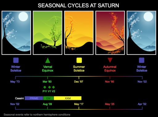
The diagram, above, shows the chronology of seasons at Saturn. It shows, notably, that the Vernal Equinox will occur in August 2009 in the northern hemisphere. Credit: David Seal, NASA / JPL-Caltech
- To get further information on that news, go to: http://saturn.jpl.nasa.gov/news/newsreleases/newsrelease20090603, http://www.newscientist.com/article/mg20227115.400-will-summer-never-end-in-titans-south.html, http://www.planetary.org/blog/article/00001973 or http://www.nature.com/nature/journal/v459/n7247/edsumm/e090604-05.html.
April 13, 2009: Researchers determine Titan's Globe appears Oblate and suggest the Existence of a Potential Subterranean Ocean
The combination of radar images has allowed scientists to generate three-dimensional views of the Titanian regions which were scanned several times by the Cassini radar mapper. As a result, a team led by Howard Zebker, a Stanford geophysicist and electrical engineer, was able to determine the topographic pattern of the Saturn moon as well as its overall shape. It turns out that the orange moon is far from being a perfect sphere as expected.
Titan appears slightly oblate, or flattened in its polar areas. This physical phenomenon results from the centrifugal force from its rotation while orbiting the ringed planet. This force is similar to the action of your foot squashing or pressing down a rubber ball which would bulge out or inflate equally on all sides in the directions perpendicular to the downward force exerted by the foot.
The shape of Titan's globe is also influenced by gravitational forces of Saturn and its numerous moons such as Dione or Rhea. Finally, it appears that the bulge of the Hazy Moon is asymmetrical with three main axes: the longest axis follows the direction of Saturn due to its tidal forces. The shortest axis, linked to the centrifugal force, is directed from pole to pole. Another axis can be discerned as well: this imaginary segment, intermediate in length, is oriented in the direction in which Titan orbits Saturn.
The ground at the poles lies approximately 700 meters ( around 2,100 feet ) below that at the equator, by using the reference of a perfect sphere. Titan is tidally locked to Saturn, always showing the same face to the Gas Giant. Therefore, the tidal force of Saturn triggers a topographic distortion at a particular location on Titan which implies that the moon is stretched out a little in Saturn's direction. The elevation level in the equatorial area varies by about 400 meters ( around 1,200 feet ). Let's recall that the mean diameter of Saturn's largest satellite is 5,150 km ( around 3,218 miles ).
Howard Zebker of Stanford University pointed out: "What we have are the first actual measurements showing that Titan's not an exact sphere. This distorted egg-shaped thing best fits the observed shape." One of the surprises from the topographic data is that the level of crushing is higher than expected. Howard Zebker insisted: "While some asymmetry is expected from Saturn's gravitational pull, there is obviously something going on that causes Titan to have a different shape than expected."
One of the main hypotheses envisaged to account for the deformity is that Titan might have had a closer orbit to Saturn. In the configuration of a closer orbit, Titan would have moved faster and spun faster, presuming it was tidally locked ( with the same hemisphere facing Saturn ). Scientists calculated that an orbit 23% closer than the current orbit of the moon would be consistent with the extra squashing at the poles and bulging at the equator.
Other potential explanations are put forward. Howard Zebker advanced "Another is that there are active geophysical processes occuring inside Titan that further distort the shape." And he concluded: "There are probably many other explanations as well, but we don't have enough information from this one experiment to be able to distinguish those."
The higher than expected "squashing" of Titan's poles could also be explained by a subsurface ocean beneath the icy crust as Howard Zebker argued: "Since the poles are squished in with respect to the equator, if there is a hydrocarbon 'water table' that is more or less spherical in shape, then the poles would be closer down to that water table and depressions at the poles would fill up with liquid." The gravitational field of the moon would influence the shape of the water table.
It is, indeed, tempting to postulate that the crust is thinner at the poles with depressions reaching the subterranean ocean of liquid hydrocarbons ( ethane, methane...). This would also explain why pools of liquids have apparently been found only in the polar regions or in the high latitudes while the equatorial band is dominated by longitudinal dune fields or Seif dunes.
However, Titan's polar areas seem to show a particularly active meteorology, apparently linked to the bodies of liquids. A giant ethane cloud formation had been identified in the north polar region where a sea and a pleiad of lakes were spotted. Infrared or near-infrared images of Titan's south polar region have also unveiled dynamic cloud formations which rapidly dissipated. And images of the south pole, captured nearly one year apart, reveal changes in dark areas that may be pools of liquid filled by seasonal rains of liquid hydrocarbons. Titan's north polar region, currently in the winter season, appears to contain the largest reservoirs of liquids.
One can envision that there are fractures, infiltrations or geysers of liquid hydrocarbons where the crust is thinner i.e. in the poles, then resulting in the formation of clouds and rain storms. In that scenario, the seas or lakes are the outcome of rains or upwelling of liquids from the subsurface ocean as Marc Lafferre notes. One can infer, also, that any meteorite crashing in the polar regions would be likely to engender new lakes or seas on condition that the outer crust is thin enough.
The hypothesis of the methane / ethane ocean beneath the icy surface accounts for the surprising abundance of methane in the atmosphere of the icy satellite. Methane is converted into other molecules, in the long run, under the action of ultra-violet radiations from the Sun. So, with an internal source such as a methane ocean, the relatively high concentration of methane in the atmosphere can be maintained or sustained by the methane molecules deriving from the subsurface ocean. The lakes identified, so far, appear insufficient to account for the current concentration of atmospheric methane. Thus, a replenishment source for that methane is suspected in the interior of the moon.
Besides, Titan's topography appears surprising with hills or mountains well below the average elevation level and plains stretching out around them at higher elevations. Howard Zebker advanced: "One of the really surprising finds that we have from this, is that the largest apparent continent is lower than the average elevation on Titan, as opposed to higher than the average elevation, as we have on the Earth." He added: "My favorite explanation is that the material that forms the mountains is simply more dense than the material surrounding them."
This implies that the material from the mountains would push down the lighter surrounding crust, hence forming topographic features at a diminished elevation level. Hills or mountains in Ganesa Macula or Hotei Arcus appear, for instance, well below the average elevation level. The large, bright, low latitude continent, the optically bright Xanadu, approximately 1000 km across ( around 625 miles across ), consisting of rugged terrains, hills and mountains turns out to lie well below the average elevation level of Titan's globe.
Finally, Titan's topography seems to follow a pattern which is opposite to the pattern of the Earth's crust. On our planet, the mountain ranges of the continental crust take shape on a material that is less dense than the material that makes up the oceanic crust. Howard Zebker argued: "The things that we would expect to exist on the surface of Titan would either be solid hydrocarbon materials, essentially frozen ethane and methane, and that is fairly light, and then frozen water ice, which is denser." He explained: "If the mountains are composed of water ice and the plain features in between are composed of these solid hydrocarbons, that could lead to this kind of a situation."
Let's note that theoretically, the presumed mountains of water ice are in an unstable state and in the long run, they are likely to "sink" into the lighter crust. Research currently conducted on the determination of Titan's gravity field could bring useful or significant information on the materials of Titan's crust.
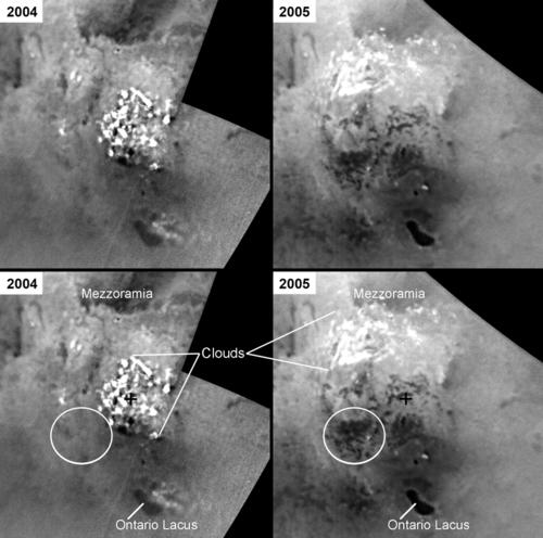
The set of infrared or near-infrared views of Titan's south polar region, above, which shows the area during a flyby in 2004 and another one in 2005 with the Cassini spacecraft shows some apparent changes. As indicated by the circle, dark patches believed to be pools of hydrocarbons have appeared between 2004 and 2005. Large, dynamic cloud formations may be responsible for the development of bodies of liquids. However, the pools could be the outcome of a cryovolcanic activity from a hypothetical subsurface ocean, as well. In that scenario, the clouds which take shape are engendered by cryovolcanic lava from the pools. This possibility is consistent with the squashing phenomenon in Titan's polar regions. Image source: NASA/JPL/Space Science Institute
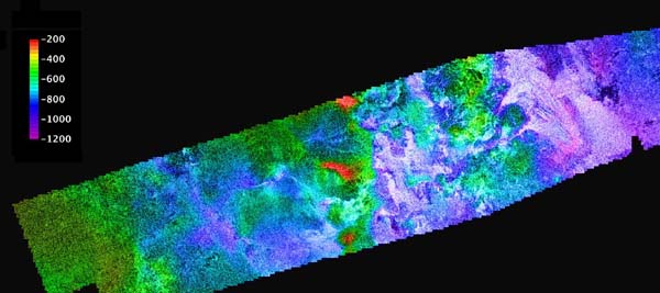
This portion of a topographic map showing the region of Ganesa Macula, above, presented by Randy Kirk of the U.S. Geological Survey in Flagstaff, Arizona, with different colors to indicate elevation levels reveals the irregular topography of Ganesa Macula which lies below the average elevation level of Titan's globe. To the east of Ganesa Macula, one can notice a low elevation area called Leilah Fluctus with two parallel channels or deltas feeding the area. It has been suggested that this radar-bright patch might be the outcome of an eruption of cryovolcanic material. The basin is located about 1,200 meters or 3,600 feet below the average elevation level. This observation is consistent with the hypothesis of a subterranean ocean.
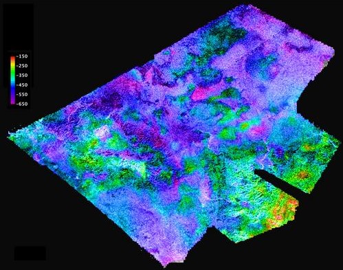
This topographic map, above, which is part of a mosaic presented by Randy Kirk of the U.S. Geological Survey in Flagstaff, Arizona, shows the area of the optically-bright Hotei Arcus. The topography of the region which is relatively irregular is well below the average elevation level of Titan's globe. Some bright channels connected to hills or mountains imply the potential occurrence of cryovolcanic eruptions. The apparent brightness of the topographic arc of Hotei Arcus suggests that the material is related to water ice or mixtures of hydrocarbons recently deposited. This hypothesis is consistent with the hypothesis of icy volcanoes fueled by an underground ocean.
- To get further information on that news, go to: http://www.astrobio.net/news/modules.php?op=modload&name=News&file=article&sid=3093&mode=thread&order=0&thold=0, http://www.newscientist.com/article/dn16894-titans-squashed-shape-hints-at-soggy-interior.html, http://www.sciencemag.org/cgi/content/abstract/1168905 and http://www.lpi.usra.edu/meetings/lpsc2009/pdf/1037.pdf
March 31, 2009: New Topographic Data notably reveals the Presumed Cryovolcano Ganesa Macula is not a Dome as previously thought
The combination of different radar images of the same regions of Titan has allowed Cassini scientists to construct topographic maps which bring a 3D representation of Titan's landscape. The Cassini spacecraft which was launched in 1997 has mapped, until now, approximately 38 percent of Titan's surface with radar. The probe is currently in extended mission operations with the Equinox mission until September 2010. The initial four-year mission ended in 2008. Scientists have gathered stereo overlaps which represent close to two percent of Titan's surface and they plan to map more than three percent of Titan's landscape in 3-D by the end of the Cassini journey.
The maps and 3-D views were generated by the Cassini radar team member Randy Kirk with the Astrogeology Science Center at the U.S. Geological Survey in Flagstaff, Arizona. Randy Kirk built the maps on the basis of the 20 or so regions where two or more overlapping radar measurements were captured during 19 Titan flybys. In other words, the topographic maps were constructed from stereo pairs of radar views. The outcome of these 3D views or representations was presented on March 24, 2004 by Randy Kirk at the Lunar and Planetary Science Conference in the Woodlands, Texas. The results of the first topographic maps appear fruitful and in some places, they are surprising and intriguing.
Topographic maps of Hotei Arcus, Ganesa Macula and the Belet region have been released online. And they reveal some topographic details which significantly improve or clarify our understanding of the moon's geology. One of the most striking features is Ganesa Macula, a round patch in radar data, about 180 kilometers wide ( around 112 miles ), which was thought to be a volcanic dome due to its apparent resemblance with volcanic domes of Venus identified by the NASA Magellan orbiter in the 1990's. However, the topographic map which shows different colors depending on the elevation level, reveals that the radar circular shape of Ganesa Macula is not a dome. The radar feature is actually dominated by low lands in its western portion and relatively high terrains in its eastern portion. The altitude or elevation level ranges from about -1,200 meters ( -3,600 feet ) below zero elevation to -200 meters ( -600 feet ) below zero elevation. The irregularity of its topography appears really surprising to most scientists who had suspected it to be a volcanic dome.
There were, yet, convincing clues for the hypothesis of the volcanic dome, especially a radar-bright central patch presumed to be the peak of the dome and a radar-bright channel connected to this peak, supposed to be a lava flow expelled from the central peak. And, of course, Ganesa Macula seemed to be circular, uniform with well defined rims. It turned out, in fact, to be a radar illusion. The hypothesis that Ganesa Macula has a volcanic origin is not abandoned: its irregular topography could be explained by significant weathering or erosional processes. Thus, Ganesa Macula may be the remnant of a cryovolcanic crater or a caldera. It could also be the outcome of a meteoritic impact. Anyway, Ganesa Macula is not a volcanic dome and its eastern boundaries show a radical change in altitude from -600 meters ( -1,800 feet ) to -1,200 meters ( -3,600 feet ) as unveiled by the topographic map with color coding. Randy Kirk pointed out, regarding Ganesa Macula: " It could be a volcanic feature, a crater, or something else that has just been heavily eroded."
In the global view of the region, to the east of Ganesa Macula, one can notice that fluvial processes or volcanic processes occur or have occured as shown by the two prominent bright triangular extensions leading to a relatively uniform area. This uniform, radar bright patch lies in a low elevation terrain at about -1,200 meters or -3,600 feet. The location seems to be fueled ( or flooded ) by the two "delta" which are supposed to act as channels to conduct the fluid from hills or higher elevation terrain to lower elevation terrain or plains. This major flow deposit and its deltas have been named Leilah Fluctus. The area of the topographic map comprising Ganesa Macula and Leilah Fluctus is centered near 50 degrees north latitude and 80 degrees west longitude.
Hotei Arcus, one of the most intriguing landscape features on Titan is also presented in another topographic map with color coding. The region of the 3D representation is centered near 30 degrees south latitude and 83 degrees west longitude. In the near-infrared or infrared spectrum, Hotei Arcus appears as a bright, semi-circular shape which is hypothesized to be linked to cryovolcanism. Robert Nelson of NASA's Jet Propulsion Laboratory in Pasadena, California, and colleagues advanced in 2005 that the bright arc, whose brightness fluctuates on timescales of several months, might be the outcome of cryovolcanic eruptions of water. But this assumption is not shared unanimously. Some scientists claim that the moon's hazy atmosphere could trigger those brightness variations.
Two radar views of a portion of Hotei Arcus were obtained, in 2008 during two separate Cassini flybys ( T41 and T43 ) and they reveal the presence of bright channels which is consistent with the cryovolcanism hypothesis. The sinuous structures or flow-like features appear to be 100 to 200 meters ( 300 to 600 feet ) thick. To a certain extent, they form, paradoxically, ridges. They dominate their surrounding in height. This geologic phenomenon can be explained by flows of water and ammonia which have frozen. On the other hand, the idea that liquid methane could have produced the channels by depositing sediment is ruled out. The shape of some channels implies that the material they have driven was at least as viscous ( stiff ) as basaltic lava on terrestrial volcanoes. Some narrow channels imply, however, the presence of flows of liquid methane, likely deriving from rainfalls. Some specialists like Marc Lafferre argue that Hotei Arcus could have been engendered by a meteorite plunging in a north south direction which could account for its bright circular shape. In that case, the bright channels would have been generated by the frozen material resulting from the heat of the impact. The presence of hills or elevated terrain in the south is consistent with this hypothesis.
A topographic map of the equatorial region Belet has also been released and it provides key information on Titan's "Sand Sea" which takes the shape of Seif Dunes. The region scanned is centered near 9 degrees south latitude and 290 degrees west longitude. The "altimetric" data suggest that the largest dunes have a height of 100 to 150 meters ( 300 to 500 feet ) which is in line with the past estimates. The topographic map shows that an elevated terrain 200 meters ( 600 feet ) high is sufficient to divert or stop the dunes. In that area of the Belet region, the total range of relief is 700 meters ( 2,100 feet ) from -400 meters ( -1,200 feet ) below zero elevation to 300 meters ( 900 feet ) above zero elevation.
Moreover, topographic data or stereo overlaps have also been obtained regarding Titan's north polar lakes of liquid ethane and methane. The stereo data reveal that the highest areas surrounding the pools of liquid are some 1,200 meters ( about 4,000 feet ) above the shoreline. On that topographic basis, scientists can estimate the potential depth of the lakes which is likely around 100 meters ( 300 feet ) or less. We can then infer the potential volume of liquid hydrocarbons present on the Saturn moon. And it is important for our understanding of Titan's atmosphere and its methane cycle ( weather, climate...).
The 3D data, put together thanks to the overlapping coverage, are really promising. Randy Kirk explained: " These flyovers let you take in the bird's-eye sweeping views of Titan, the next best thing to being there."..."We've mapped many kinds of features, and some of them remind me of Earth. Big seas, small lakes, rivers, dry river channels, mountains and sand dunes with hills poking out of them, lava flows."
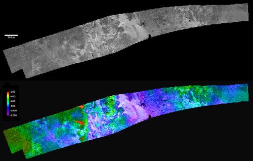
The composite image above, proposed by Randy Kirk of the U.S. Geological Survey in Flagstaff, Arizona, shows the region of Ganesa Macula and Leilah Fluctus. The black and white portion corresponds to the radar view of the area and the color view corresponds to the same region with topographic data. Ganesa Macula is the round feature of the radar view in the western portion of the strip. Leilah Fluctus is the bright patch with two western extensions in the middle of the radar view. Image source: NASA/JPL/USGS
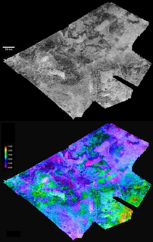
The composite image above, presented by Randy Kirk of the U.S. Geological Survey in Flagstaff, Arizona, shows the region of the optically bright Hotei Arcus. The black and white view corresponds to the radar coverage of the area. One can observe, notably, intriguing bright channels and hills or mountains to the south. The color view corresponds to the radar view with topographic data revealed by a color coding. Image source: NASA/JPL/USGS
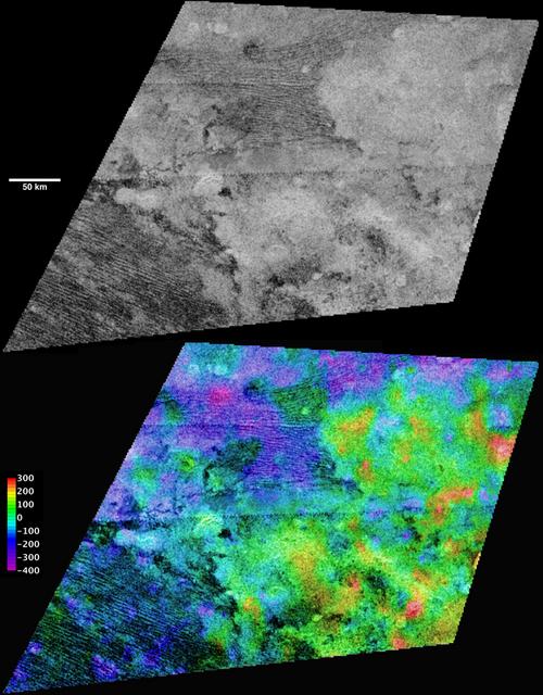
The set of images above, proposed by Randy Kirk of the U.S. Geological Survey in Flagstaff, Arizona, unveils a portion of the equatorial region Belet. The black and white view corresponds to the radar image of Belet. The color view shows the same radar view of the region with topographic data provided by a color coding. One can notice, especially, the typical Sand Seas encountered in the low latitudes of the moon with linear and parallel dune fields. The hills or elevated terrains tend to divert or stop the movement of dunes. Image source: NASA/JPL/USGS
- To get further information on that news, go to: http://saturn.jpl.nasa.gov/news/newsreleases/newsrelease20090324 and http://www.newscientist.com/article/mg20127014.400-giant-ice-flows-bolster-case-for-volcanoes-on-titan.html
March 2, 2009: General Orientation and Characteristics of Titan's Dune Fields imply Prevailing Winds blow Eastward
Scientists have compiled radar data collected over a four-year period to account for the general direction of dominating winds at equatorial latitudes. Radar data obtained by the radar mapper of the Cassini spacecraft show that the equatorial regions are dominated by what appear to be longitudinal dune fields. Those dune fields which resemble "Seif Dunes" on Earth like those in the Namib Desert are generally oriented from the west to the east. Their characteristics and orientations suggest that dominating winds blow from the west to the east which is not consistent with previous circulation models suggesting an opposite direction.
The longitudinal dunes can extend over hundreds of km. The action of prevailing winds is clearly understood when the course of the dune fields is deflected by topographic obstacles like icy hills, mountains or ice sheets. The natural obstacles often appear bright in radar and near-infrared images which implies that they are probably composed of icy particles. The winds apparently act, as well, on the icy elevated terrain which deflects the orientation of the dunes: some icy particles are pushed by the winds and mix with the particles of the dunes. As a result, the neighbouring dunes present a brighter appearance and the shape of the icy patches is strongly influenced by the dominating winds as the radar view of the December 21, 2008 flyby shows.
This radar portion which was captured by the Cassini radar mapper is located in the lower part of the Belet region, centered near 19.2 degrees south and 257.4 degrees west. The shape of the dunes implies that the winds locally come from the west and north-west. Titan's dune fields were first identified during the T3 flyby on February 15, 2005 in radar images of the north-east of the optically bright Xanadu. Scientists called those topographic features "Cat Scratches" due to their resemblance with cat scratches. Scientists were delighted to collect this precious information closely linked to wind patterns. Their previous global circulation models had simulated westward winds that is the opposite of the real wind pattern.
Ralph Lorenz, Cassini radar scientist at Johns Hopkins University Applied Physics Laboratory in Laurel, Maryland points out: " At Titan there are very few clouds, so determining which way the wind blows is not an easy thing, but by tracking the direction in which Titan's sand dunes form, we get some insight into the global wind pattern."
As a matter of fact, dune fields act like weather vanes, informing on the general direction of winds. There is no clear indication on whether the winds are permanent or occasional and as dune fields are the outcome of the action of dominating winds in the troposphere , we don't get information on secondary winds or "dominated winds". Probably that the direction of the winds is influenced by topographic obstacles or by the nature of landforms. That's what suggests, particularly, the radar portion of the December 21, 2008 flyby. And it appears that the global wind pattern results from the action of different winds which join their forces and merge to form the global winds which blow eastward.
Jani Radebaugh, Brigham Young University, Provo, Utah advanced: " Titan's dunes are young, dynamic features that interact with topographic obstacles and give us clues about the wind regimes."..." Winds come at these dunes from at least a couple of different directions, but then combine to create the overall dune orientation."
Approximately, 20 radar images have been acquired, digitized and combined to generate a new map based on all the high-resolution radar data obtained during a four-year period. 16,000 dune segments were identified. Titan's dune fields which are wide-spread in the radar-dark regions of the equatorial latitudes comprised, roughly between 30 degrees north latitude and 30 degrees south latitude, are probably composed of hydrocarbon sand grains.
Carl Sagan had hypothesized the presence of a mixture of hydrocarbons called Tholin. Titan's organic haze may be closely related to the hydrocarbons present on the soil. The exact nature of the hydrocarbon-made particles of the dunes is still unknown. Nevertheless, the complexity of some carbon-made molecules in Titan's atmosphere implies that the hydrocarbon sand grains could be made of complex hydrocarbons, as well. They could also be fed by methane or ethane rain that is likely to occur periodically.
Some scientists believe that hydrocarbon sand grains accumulate and pile up in the equatorial region because the environmental conditions are drier which makes it easier for particles to be transported by the winds. The radar and near-infrared views of Titan's globe show that the polar regions of Titan are, by far, wetter than the equatorial region. The contrast is obvious: the north polar region harbours a giant ethane cloud formation similar to a hurricane on Earth and the south polar region harbors very dynamic cloud formations which rapidly dissipate. And a large number of pools of liquid have been spotted both in the south polar region and in the north polar region. Therefore, the conditions in those exotic areas are not ideal for creating dunes. The movement of the winds in those regions will be better monitored on the basis of the orientation of clouds or landscape features such as drainage channels.
As the vernal equinox on Titan and the change in seasons approach, it will be interesting to examine the potential weather changes. The north polar region, currently in the winter season will turn to summer while the south polar region, currently in the summer season will turn to winter. Some scientists anticipate significant movements or migrations of clouds between the north pole and the south pole. Will there be evaporation of ethane or methane in the high northern latitudes ? Will there be formations of larger bodies of liquid in the south pole ? Will there be ethane or methane showers or "monsoons" in the equatorial latitudes ? If so, what will happen with the equatorial dune fields ? Will they be erased from the map, gobbled by seas or lakes of hydrocarbons ?
The Cassini spacecraft which started its journey to the Saturn system in 1997 is now in extended mission operations with the Equinox Mission from 2008 to 2010. Titan is scheduled to be visited, in 2009, seventeen times via seventeen Cassini flybys. So, new opportunities to analyse the weather changes will take shape. Scientists are eagerly awaiting the northern vernal equinox which will occur in August 2009.
The orientation of winds and the climate and weather of the moon are crucial for the prospect of next missions to Titan: the next planetary venture to Titan could send a lander and an exploration balloon to the orange moon. A paper based on the studies regarding the wind patterns appeared in the February 11 issue of Geophysical Research Letters.
As we've said, the nature of what are believed to be dune fields is still unclear. Some specialists have suggested the presence of a subsurface ocean with streams acting on the shape of dune fields. Marc Lafferre notes:" The parallel dunes are separated by radar-dark streaks or grooves which mark a radical contrast with the dunes. That suggests that the dark streaks might be humid. We could envisage that the dunes are laid on a pond-like surface or that some fractures appear between the dunes with infiltrations and upwelling of liquid hydrocarbons coming from the hypothetical underground ocean."
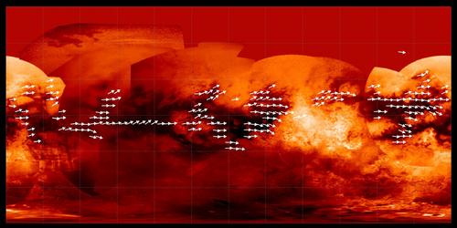
This global map of Titan above, made of near-infrared views and appearing in false color, shows the direction of prevailing winds in the equatorial latitudes. The orientation of dominating winds, indicated by white arrows, appears to be eastward, from the west to the east which contradicts previous circulation models. The wind patterns were inferred from the shape of longitudinal dune fields which are wide-spread in the radar-dark areas of Titan's low latitudes. The dune fields were clearly identified with the radar mapper of the Cassini probe which examined the moon over a four year period. Image source: NASA / JPL / Space Science Institute
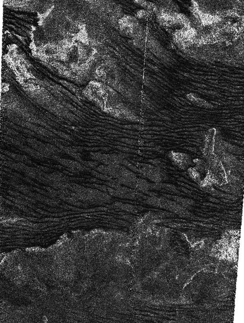
The radar portion above captured by the Cassini radar mapper on December 21, 2008 reveals some longitudinal dune fields in the south of the Belet region. The view is centered near 19.2 degrees south and 257.4 degrees west and is 220 kilometers ( 137 miles ) long by 170 kilometers ( 106 miles ) wide. North is roughly up. This radar view clearly shows the interaction between the winds, the dunes and the bright topographic obstacles. A plateau or a plain can be deduced in the lower portion of the radar image. Image source: NASA / JPL
- To get further information on that news, go to: http://saturn.jpl.nasa.gov/news/newsreleases/20090226titandunes
February 4, 2009: Cassini Observations of Titan's South Polar Region apparently show New Lakes generated by Rainfall
Cassini near-infrared images and Earth-based observations of Titan's south polar region show cloud formations and dark patches suspected to be bodies of liquid ethane or methane. A study published on January 29, 2009 in the journal Geophysical Research Letters identifies new lake features not observed in views of the same region captured a year earlier.
The finding is based on differences in two infrared images of Titan's south polar region, one taken on July 3, 2004 and the other obtained on June 6, 2005. The images reveal tropospheric clouds which turn out to be very dynamic, appearing in different locations in the 2004 observation and the 2005 observation. The 2005 view shows large dark patches which were not visible in the 2004 image. Those dark patches are likely new lakes filled during a recent rainstorm. This hypothesis is strengthened by the presence of extensive cloud systems covering the region in the time that elapsed from the first observation to the second observation. As a result, the weather and changing seasons may act on the size and distribution of lakes across Titan's surface.
Most of Titan's topography has now been scanned by the high-resolution cameras of Cassini's Imaging Science Subsystem ( ISS ). An updated map of this Saturn moon was released on January 29, 2009: it notably incorporates the first near-infrared views of the leading hemisphere portion of Titan's northern "lake district" obtained on August 15 or August 16, 2008. It also includes a simple cylindrical projection of the globe as well as a south polar projection and a north polar projection ranging from 55 degrees latitude in the hemisphere to 90 degrees latitude in the same hemisphere.
Scientists have now gathered high resolution ISS data, VIMS data and radar data. The confrontation of infrared data and radar data appears fruitful in our understanding of Titan's topography and meteorology. Radar and infrared data gathered by the Cassini probe tend to suggest that the north polar region is currently wetter than the south polar region: Titan's south polar area is dominated by what appears to be a large pool of liquid approximately 235 km across ( 147 miles ) and 20,000 km² in area ( 7,813 square miles ) named "Ontario Lacus". By contrast, Titan's north polar region is covered by several large bodies of liquid, of which one can be regarded as a sea. The largest pool is Kraken Mare, probably around 400,000 square kilometers in size which is nearly five times the size of North America's Lake Superior. In the "Arctic region", one can also mention Ligeia Mare and Punga Mare as large bodies of liquid. The cumulated size of Titan's north polar dark patches observed by ISS and believed to be lakes or seas, attains more than 510,000 square kilometers which almost represents the size of France. It's also nearly 40 percent larger than Earth's largest lake, the Caspian Sea.
The relatively higher content of liquid hydrocarbons in the north polar region may be explained by seasonal phenomena. The Arctic region is presently in the winter season while the south polar region is in the summer season. However, the northern hemisphere is approaching the summer season which is likely to have strong implications for the meteorology in that specific region due to the potential high amount of evaporation from the lakes or seas. Furthermore, what will happen to the giant "ethane hurricane" that is engulfing the entire north polar region ? Cassini scientists foresee that large convective cloud systems will develop there engendering greater amounts of precipitation than that deduced in the south polar region. Thus, the northern lakes could be replenished by the rains of hydrocarbons.
Scientists are convinced that the presence of methane in Titan's atmosphere is not only linked to meteorology and the cycle of hydrocarbons from the lakes to the clouds. There is likely an interior source which fuels the atmosphere with methane or other hydrocarbons because evaporation from the pools is not great enough to sustain the amount of methane we observe today. The methane molecules can fall as rain or reach the surface in the form of methane-derived haze particles.
Dr. Elizabeth Turtle, Cassini imaging team associate at the Johns Hopkins University Applied Physics Laboratory in Laurel, Maryland and lead author of the new publication pointed out:" A recent study suggested that there's not enough liquid methane on Titan's surface to resupply the atmosphere over long geologic timescales." She added:" Our new map provides more coverage of Titan's poles, but even if all of the features we see there were filled with liquid methane, there's still not enough to sustain the atmosphere for more than 10 million years."
On that basis, the hypothesis of underground methane reservoirs is put forward. Will we find geysers or cryovolcanoes involving the release of methane or other hydrocarbons ? Titan's atmosphere is poorly understood. Elizabeth Turtle insisted:" How long Titan's atmosphere has existed or can continue to exist is still an open question."
The observations of Titan's landscape or topography provide , in an indirect way, precious information on winds and meteorology. The dark equatorial regions are, to a large extent, drawn by winds which generate large dune fields or Seif over hundreds of km. A few Cirrus-like clouds have been identified at mid-latitudes and as we've said, large cloud formations develop and move in a very dynamic way, over the south polar region. The distribution of liquids on the surface is intimately linked to the meteorology. Scientists are now trying to clearly understand why liquids concentrate at the poles rather than low latitudes where the landscape is dominated by dunes.
Dr. Tony DelGenio of Nasa's Goddard Institute for Space Studies in New York, a co-author and a member of the Cassini imaging team advanced:" Titan's tropics may be fairly dry because they only experience brief episodes of rainfall in the spring and fall as peak sunlight shifts between the hemispheres." He concluded:" It will be interesting to find out whether or not clouds and temporary lakes form near the equator in the next few years." A Titan year is long, representing about 29 years which implies that the seasons are long. Moreover, the obliquity of the Saturn moon is over 26 degrees which makes the seasons well pronounced . This probably has strong implications on the circulation of cloud systems.
The W.M. Keck II telescope using adaptive optics had already identified dynamic cloud formations near Titan's south pole at the end of 2001 and in the first half of 2002. It had also unveiled a south polar cap , a relatively bright blanket covering the south polar region as in the north pole today. Henry Roe, a post-doctoral fellow at the time of the observations of 2001-2002, pointed out:" We see the intensity of the clouds varying over as little as a few hours... The clouds are constantly changing, although some persist for as long as a few days."

The mosaic, above, showing Titan's south polar region is composed of infrared views obtained on July 3, 2004 and on June 6, 2005. It reveals dynamic cloud formations and the apparent formation of new lakes in the 2005 observation. The lakes which lie in an encircled area are probably the outcome of a major rainstorm in the time that elapsed between the two observations. Image source: NASA / JPL / Space Science Institute
This set of Titan views, above, captured by the W.M. Keck II telescope using adaptive optics, in late 2001 and at the beginning of 2002 shows dynamic and rapidly changing bright clouds in the south polar region of Saturn's largest moon. At the time of the observations, Titan is in the midst of southern summer, and the south polar area has been in continuous sunlight for more than six terrestrial years. The views were proposed by M.E. Brown, A.H. Bouchez and C.A. Griffith.
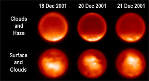
This set of Titan images, above, acquired on December 18, 20 and 21, 2001 reveals surface and atmospheric features. The relatively bright continents of Titan can be clearly spotted in the three global views in the lower row. In the upper row, the three global views unveil the presence, in the south polar region, of dynamic cloud formations represented by bright patches as well as a relatively bright blanket of haze covering the south polar area. The views were proposed by H.G. Roe, I. de Pater, B.A. Macintosh and C.P. McKay.
- To get further information on that news, go to: http://saturn.jpl.nasa.gov/news/newsreleases/20090129Titan and http://berkeley.edu/news/media/releases/2002/12/18_titan.html
Titan News 2008
Titan
News 2007
Titan
News 2006
Titan News
2004, 2005